Great run of north-east swell

Eastern Tasmania Surf Forecast by Craig Brokensha (issued Friday 2nd July)
Best Days: Saturday through Wednesday
Features of the Forecast (tl;dr)
Recap
- Strong NE swell tomorrow AM, easing with fresh N/NW winds
- Steady NE swell Sun with NW tending W winds
- Good NE pulse for Mon with W tending variable winds
- Late pulse of NE swell for Tue with a building S swell and early W/SW tending strong S winds
- Easing mix of E/NE and S swells Wed with W/NW tending variable winds
This weekend and next week (Jul 3 - 9)
We've got a great run of NE swell for the coming period from quite an out of season setup, so make the most of it.
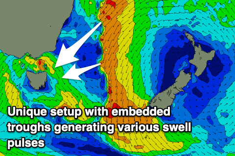
 What we'll see is a strong, stubborn high across New Zealand with surface troughs and lows squeezing its western flank from this evening through the weekend, with the setup finally breaking down and slipping south-east on Monday.
Prolonged NE winds aimed through our swell window will setup an active sea state and these embedded lows and bursts of stronger gales will generate multiple embedded pulses of larger groundswell.
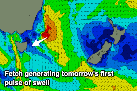
The first little intensification looks to come through today and this has brought forward tomorrow's pulse of swell, with north-east magnets due to come in at 4-5ft+ in the morning, easing through the day.
The swell looks to now steady Sunday around the 4ft range on the sets across the swell magnets.
Into Monday another slightly stronger pulse of NE groundswell is due from a strengthening of the fetch through the Tasman Sea Saturday evening and Sunday.
There's an even stronger pinch of winds Sunday evening up more in the Coral Sea that will drift south, producing a third pulse of swell for late Tuesday/Wednesday.
 Coming back to Monday's pulse and stronger 4-5ft+ sets are due, easing back slightly Tuesday morning, with the final pulse pushing back to 4-5ft later in the day, easing from 4ft Wednesday.
Winds through the period vary, with a fresh N/NW'ly on Saturday, NW tending W on Sunday and then W tending variable on Monday. Our strong S'ly change for Tuesday is on track, though early winds look W/SW, followed by W/NW tending variable winds Wednesday.
Tuesday's change will also bring a fun S'ly swell with it, generated as a polar front pushes up and past us, with building sets to 3ft, easing back from 2-3ft on the south magnets Wednesday.
Longer term, once the NE swell fades, small pulses of S'ly swell are due to pad out the week, but more on this Monday. Have a great weekend!