Easing SE groundswell ahead of extended NE swell

Eastern Tasmania Surf Forecast by Craig Brokensha (issued Wednesday 30th June)
Best Days: Tomorrow northern corners, Saturday onwards well into next week
Features of the Forecast (tl;dr)
- Easing SE groundswell tomorrow with N/NW winds
- Building mid-period NE swell event Sat, strongest in the PM and Sun AM, easing a touch Mon with a stronger pulse from the NE Tue
- N/NW winds Sat, W/SW tending S Sun, W on Mon and strong S Tue
Recap
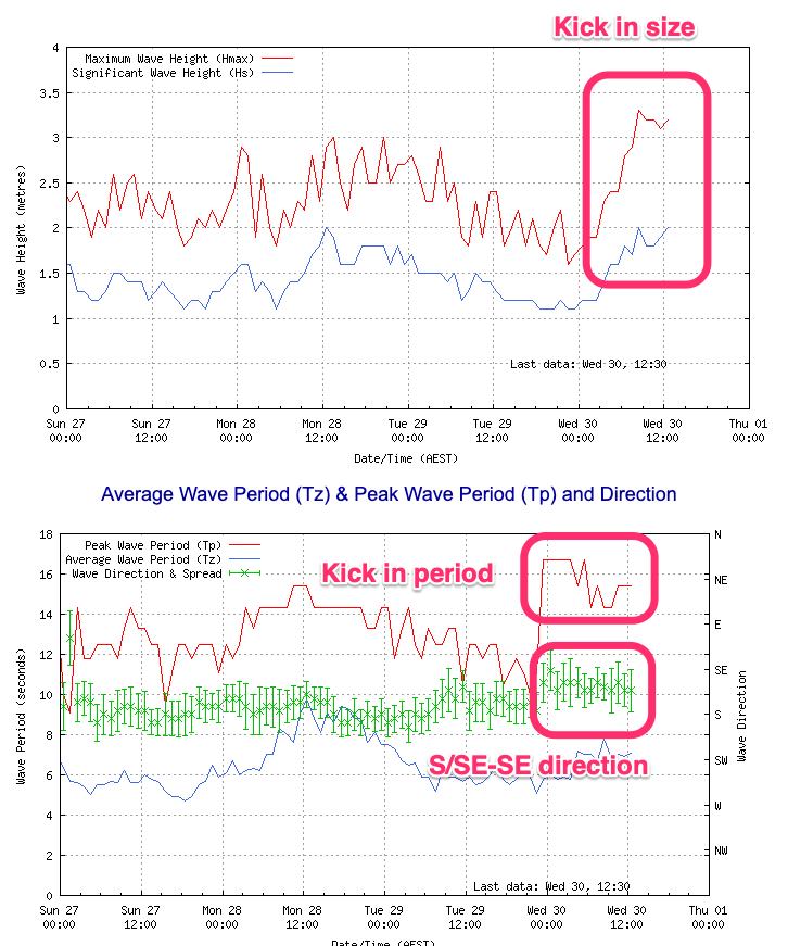
Easing S'ly swell yesterday with clean conditions but our new SE groundswell for today has come in strong with great 4-5ft sets across exposed breaks with favourable winds.
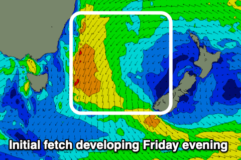
You can see the swell clearly on the Maria Island buoy..
This week and next (Jul 1 - 9)
The strong SE groundswell breaking across the coast today is peaking and we'll see it easing off in size slowly tomorrow.
Open beaches should still see good 3ft to possibly 4ft sets tomorrow morning, though less consistent, smaller into the afternoon, 1-2ft max Friday.
A persistent fresh N/NW breeze will favour northern corners tomorrow, similar Friday.
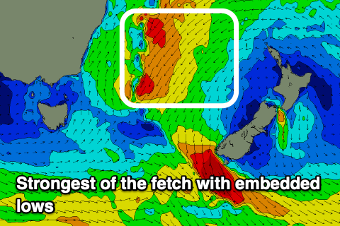
Now, moving into the weekend and we're looking at our building NE swell and this looks to be quite a prolonged swell event owing to the slow moving nature of surface lows and coastal troughs squeezing a stubborn high over New Zealand.
 This setup will develop from tomorrow as a strong high positions itself over New Zealand, squeezed on both its western and north-western flanks.
We'll see a persistent fetch of strong NE winds aimed through our swell window, from the Tasman Sea up to the Coral Sea, above New Zealand, with various intensifications as embedded lows and troughs try to push it slowly east and away from us.
We'll effectively see building levels of moderate sized mid-period NE swell from late Friday but more so Saturday through until the middle to end of next week.
At this stage the weekend looks to come in around 4ft+ or so from Saturday afternoon, through Sunday morning, with Monday dropping a touch more to 4ft or so.
 The largest pulse is due Tuesday from the strongest winds through the northern Tasman Sea Sunday evening, linked to the embedded lows. Sets to 4-6ft are likely on the swell magnets, but we'll confirm this over the coming days.
Locally, winds look favourable owing to the swell generating system staying at arms length, with N/NW winds due Saturday, W/SW tending S on Sunday. Monday should see W'ly winds all day while a trough will bring a gusty S'ly change Tuesday, favouring southern corners which will be biggest. More on all of this in Friday's update.