Upgrade in coming easterly swell

Eastern Tasmania Surf Forecast by Craig Brokensha (issued Wednesday 16th June)
Best Days: Tomorrow, protected southern corners Friday and Saturday, Sunday, Monday
Features of the Forecast (tl;dr)
- Fun mix of E swells tomorrow with W/SW tending fresher S/SW-S winds
- Large E swell pulse for Fri with strong S/SE winds
- Secondary larger E pulse for Sat AM with fresh to strong S/SE winds, easing Sun with W tending NE winds
- Smaller easing surf Mon with W winds
Recap
Tiny yesterday, with a fun pulse of E/SE swell today with variable winds and wet weather.
This week and weekend (Jun 17 - 20)
We'll see today's pulse of E/SE swell ease back in size tomorrow, though there'll be some reinforcing energy for the afternoon with surf to 2ft+ due all day.
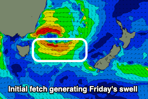
Also in the mix will be the start of a building E'ly swell event from a deepening Tasman Low, with some new windswell emanating from a strengthening E/NE fetch sliding down past us this evening.
 Peaky 2-3ft waves are due and with W/SW-SW offshore winds, shifting S/SW-S into the afternoon. With these conditions open beaches should be fun and worth a surf.
As we move into tomorrow evening we'll see stronger E'ly winds develop on the southern flank of the low, nearly reaching gale-force, producing a rapid spike in larger E'ly swell through Friday to 5-6ft across open beaches.
Winds will be strong from the S/SE though on Friday though limiting surfing options to protected southern corners.
As the low continues to strengthen Friday we'll see SE gales aimed through the edge of our eastern swell window, producing a larger, reinforcing E/SE swell Saturday to possibly 6ft+, then easing off slowly into the afternoon and further through Sunday and Monday.
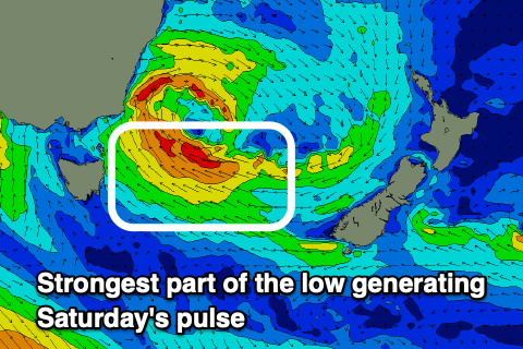 The easing trend will be slowed by persistent, strong SE winds through the lower Tasman Sea Saturday, swinging more north and out of our swell window Sunday.
Size wise, open beaches should still be a good 4ft+ Sunday morning, easing from 3ft on Monday.
Winds will remain gusty from the S/SE on Saturday but improve Sunday and tend W/SW ahead of weak NE sea breezes as the low shifts east. Monday looks great with W'ly offshore winds.
Longer term we may see another mid-latitude low bringing a building E/NE swell late next week, the third in a row, but more on this next update.
Comments
How’s the swell looking Craig?