Plenty of east swell this period

Eastern Tasmania Surf Forecast by Craig Brokensha (issued Monday 14th June)
Best Days: Wednesday morning, Thursday, Friday and Saturday in protected spots, Sunday and Monday
Features of the Forecast (tl;dr)
- Fun E/SE swell Wed with NW tending fresh NE winds, a touch smaller Thu but steadying with W/SW tending S winds
- Building E swell Fri with strong S/SW tending S/SE winds, similar Sat with a touch more, building swell
- Biggest Sun out of the E/SE with W/SW tending variable winds
Recap
Good waves all weekend with workable winds Saturday and a moderate-large E'ly swell, easing through the day and smaller but fun yesterday. Today there's not much left in the tank.
This week and weekend (Jun 15 - 20)
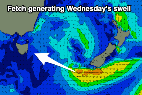 With the E'ly swell from the weekend fading, due to the weakening of the stubborn low pressure system that dominated our weather last week breaking down and pushing east, we've still got one final pulse of fun E/SE swell on the cards Wednesday.
A fetch of strong E'ly winds were generated this morning south of the South Island, producing a mid-period E/SE pulse Wednesday to 2-3ft. This should ease into Thursday but lingering E/SE winds through tomorrow afternoon should generate another weaker pulse for the afternoon, keeping wave heights around 2ft.
At the same time as these swells fill in we'll see another trough and low forming off the southern NSW coast, forming into a broad Tasman Low on the weekend.
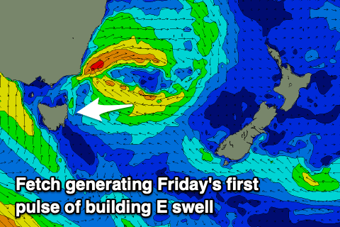 An infeed of E'ly winds on the southern flank of the low looks to generate some fun E'ly swell initially Friday afternoon but as the low broadens and strengthens, additional better levels of E/SE swell are due into the weekend.
Winds during the first phase of the evolution of the low are tricky with a morning NW breeze Wednesday, shifting NE and freshening through the day, then around to the W/SW-S/SW on Thursday.
Friday looks average with strong S/SW tending S/SE winds which may persist on Saturday, back offshore on Sunday.
Size wise the E'ly swell should build to the 3ft range Friday afternoon, increasing a little further and strengthening in power Saturday with building sets to 4ft into the afternoon. Sunday looks strongest with 4ft+ sets, then easing slowly into next week.
Check back here Wednesday for an tweaks to the size or local winds.