Large, stormy surf to end the week

Eastern Tasmania Surf Forecast by Craig Brokensha (issued Wednesday 9th June)
Best Days: Protected spots over the coming days, Saturday, Sunday
Features of the Forecast (tl;dr)
- Large, stormy SE tending E/SE swell tomorrow with strong SE winds, easing slowly Fri with strong SE winds, tending S/SE late
- NE swell in the mix as well Thu
- Reinforcing mod-large E swell for Sat AM with fresh and gusty S/SE tending S/SW winds, easing Sun with W/SW tending S winds
Recap
Easing, small N/NE windswell waves yesterday, while today winds are strengthening out of the S'th on the coast as a broad, cold low deepens to our north-east.
This week and weekend (Jun 10 - 13)
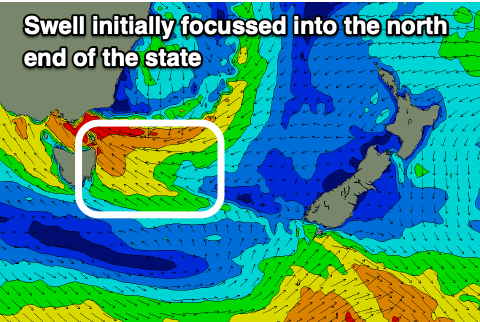
As the low strengthens directly north-east of us today and this evening, we'll see a strong to near gale-force fetch of SE winds developing across our north-east tip, with weaker winds the further south you head.
This will result in the most size being seen across the northern end of the state, but also with the most wind.
During tomorrow the low is due to dip slowly south while weakening. This will see strong E/SE winds moving south, then backing off late afternoon and remaining so into early Friday.
 A re-intensification of the low east of us during Friday will see strong E'ly winds projected towards us, breaking down into the evening and further Saturday.
So what we can expect is large, stormy surf out of the SE tending E/SE tomorrow, coming in at 6-8ft+ across the northern extent of the coast, smaller to the south. Conditions will be poor though with strong SE winds due through most of the day, persisting Friday but turning S/SE near dark.
It's worth noting there'll be some additional NE swell in the mix Thursday from an infeed of NE winds on the eastern flank of the low today, but it'll be below the local E swell.
A more even spread of size out of the E is due Friday to 6ft, easing through the day.
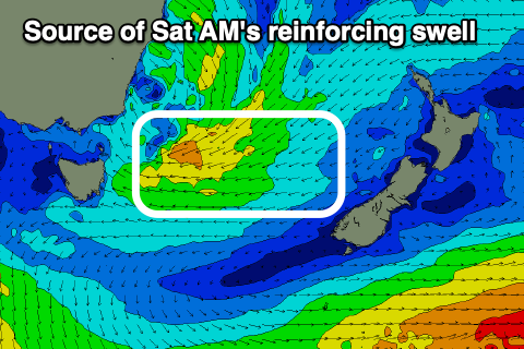 The re-intensification of winds east of us should produce a fresh pulse of E'ly swell Saturday morning to 6ft across open beaches, easing through the day, then down from 3ft Sunday morning.
Winds should improve Saturday and swing from a fresh S/SE'ly to the S/SW during the day as the low slips further south, then W/SW tending S'th on Sunday.
Beyond this there's nothing too major on the cards but there are a couple of swell sources to keep an eye on. More on this Friday.