Lots of swell, but generally poor conditions

Eastern Tasmania Surf Forecast by Craig Brokensha (issued Monday 7th June)
Best Days: Protected spots Thursday through Saturday, Sunday
Features of the Forecast (tl;dr)
- Small, fading N windswell tomorrow with fresh to strong N/NW winds, easing late
- Stormy, building S/SE swell late Wed with strengthening S tending S/SE winds
- Large, stormy E/SE tending E swell for Thu, easing slowly Fri and further Sat with strong SE-S/SE winds
- NE swell in the mix as well Thu
- Cleaner surf Sun with fresh S/SW winds, but small, easing E swell
Recap
Nothing of note over the weekend and today a weak, N'ly windswell may have been seen across the coast this afternoon.
This week and weekend (Jun 8 - 13)
Dynamic, that's the outlook for the coming period.
Firstly, off-axis and unconsolidated winds out of the N'th this afternoon and evening should generate some flukey N'ly windswell tomorrow to 1-2ft across north-east swell magnets, fading through the day. Winds are less than ideal and will be fresh to strong from the N/NW most of the day, easing late in the day ahead of an evening change, likely after dark.
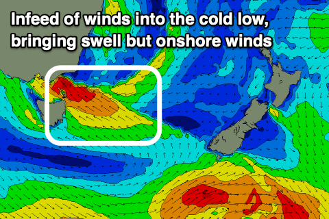
Of greater significance is a deep cold pool of air moving up and across the south-east of the country tomorrow, then spawning into a broad, deep low pressure system just north-east of us on Wednesday.
This will see strong to gale-force SE winds develop off the Gippsland coast in Victoria, becoming weaker the further you move down our coast and only coming in strong to the south.
 We're due to see the low drift slowly south through Thursday, swinging winds more E/SE, followed by the low slowly weakening Friday but maintaining a fetch of strong E/SE winds through our eastern swell window.
The low isn't expected to totally breakdown until Saturday/Sunday, when winds will drop below being strong enough to generate swell.
While we're set to see a prolonged storm swell event out of the east, the slow and stalling movement will see poor conditions through most of the swell episode.
Wednesday will start slow but a late, rapid increase in size out of the SE is due as the low strengthens and gale-force winds develop to our north, with Thursday likely to come in at 6-8ft across the northern half of the coast but with strong S/SE winds, shifting more SE near dark.
Strong SE winds will persist on Friday, possibly tending S/SE at times as the swell eases from 6ft to possibly 8ft across open beaches, dropping from 4-6ft Saturday with strong, persistent S/SE winds.
It's worth noting there'll be some additional NE swell in the mix Thursday from an infeed of NE winds on the eastern flank of the low Wednesday, but it'll be below the local E swell.
It looks like we'll finally see winds swing S/SW on Sunday but with smaller, easing surf from a weaker 3ft+ or so. More on this in the coming updates though as this low is still quite dynamic and any shift in position could see a good improvement in the local winds.