Easing southerly swell

Eastern Tasmania Surf Forecast by Craig Brokensha (issued Friday 16th April)
Best Days: South magnets tomorrow, Sunday morning and Monday
Features of the Forecast (tl;dr)
- Easing S swell tomorrow with fresh W/NW winds
- Flukier, inconsistent and acute S'ly groundswell for Sun and Mon AM, moderate W tending E winds Sun, strong N/NW Mon
Recap
Tiny surf yesterday and similar this morning but a new S'ly groundswell should now be showing on the coasts south swell magnets.
This weekend and next week (Apr 17 - 23)
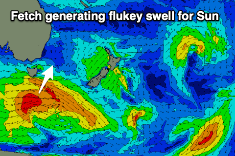
Satellite observations of the swell generating fetch linked to today's building S'ly groundswell were great and we should see sets hitting 4-5ft on the regional south magnets by later today.
 The swell will ease back through tomorrow but we should still see 3-4ft sets across the south magnets, small to tiny elsewhere and with a steady drop in size through the day.
Conditions will be clean though with a persistent, fresh W/NW breeze.
The flukey, follow up S'ly groundswells for Sunday and Monday are now looking a touch better.
The source of these two swells are strengthening, zonal fronts that are currently moving in from the west under the country.
The first will be strongest and project slightly east-northeast through our swell window, producing an inconsistent, though surfable S'ly groundswell Sunday to 2ft to possibly 3ft across the regional south swell magnets, similar Monday with the secondary pulse of swell.
All other locations will be flat and keep your expectations low with these pulses.
Conditions will be clean in the mornings with a W'ly breeze Sunday, ahead of E'ly sea breezes, strong N/NW through Monday.
The S'ly swell will fade Monday afternoon with tiny surf left into Tuesday and longer term, a significant W/SW groundswell is due to impact the state late next week, but for the time being it looks too west for us.
More on this Monday though. Have a great weekend!