Small swells ahead of some better energy late week

Eastern Tasmania Surf Forecast by Craig Brokensha (issued Monday 12th April)
Best Days: South magnets for the desperate tomorrow morning, Wednesday morning, Friday, Saturday
Features of the Forecast (tl;dr)
- Small, easing S swell tomorrow with W/NW tending fresh N/NW winds
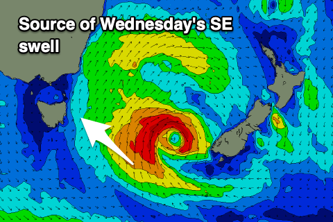
- Fun SE swell Wed AM with strong N/NW tending W/NW winds
- New S groundswell for Fri with W/SW tending variable winds, easing Sat with W/NW winds
Recap
Nothing over the weekend or yesterday morning but some new swell should have kicked into yesterday afternoon on the south magnets, coming in at a slightly better direction today but only surfable across the regional magnets.
This week and weekend (Apr 13 - 18)
 The south swell seen yesterday afternoon and today will ease back in size tomorrow with not much left in the tank at dawn. Try south magnets up the coast for a small, clean 2ft+ wave under a light W/NW tending fresh N/NW breeze.
A small intensification of S/SE gales to our east-southeast this evening should produce a small pulse of SE swell for Wednesday but only to 2-3ft or so in the morning, fading into the afternoon. Winds look strong from the N/NW, shifting W/NW through the day so try northern corners.
The surf is due to become flat into Thursday, but come Friday a strong polar front being dragged up by a mid-latitude low pushing across us should bring a good increase in S'ly groundswell.
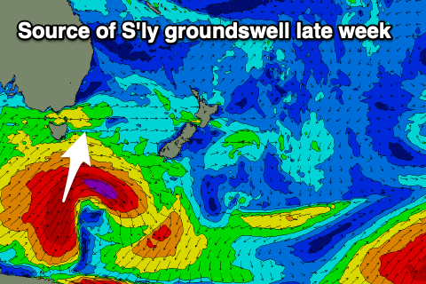 A drawn out fetch of gale to severe-gale S/SW winds should produce a good spike in size Friday with south facing beaches coming in at 4-5ft along with W/SW tending variable wind. The elongated nature of the swell generating front should keep fun sized surf to 3-4ft hitting the coast Saturday morning, easing through the day and with more favourable W/NW winds.
Following this the outlook is slower with a zonal setup due across the coast. More on this Wednesday.