Significant north-east swell on the way

Eastern Tasmania Surf Forecast by Craig Brokensha (issued Monday 22nd March)
Best Days: Experienced surfers Thursday, Friday
Features of the Forecast (tl;dr)
- NE windswell tomorrow
- Rapid increase in large NE groundswell Wed, peaking overnight and easing Thu out of the E/NE, small Fri
- Strong to gale-force E tending SE winds Wed, tending fresh W-W/NW on Thu, remaining offshore Fri
Recap
The E/NE swell muscled up a bit in size on Saturday with better 2-3ft waves on the coast with a workable onshore breeze, similar Sunday with a touch more energy again. Today conditions are bumpy and the swell is up a little more.
This week and next (Mar 23 - 28)
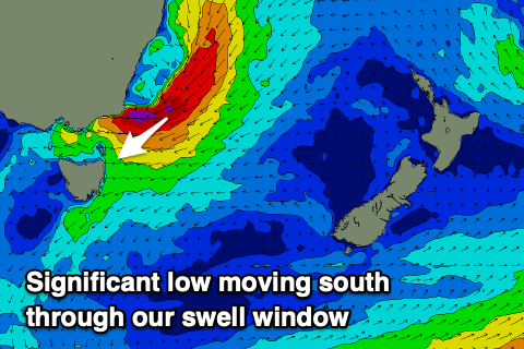
Looking at the current synoptic setup and we've got a strong stubborn high feeding in moisture from the Coral Sea onto the Australian mainland. Coastal instability is bringing the constant, torrential rainfalls and one of these troughs is expected to form into a low as it pushes off the coast tomorrow evening.
What this will do is direct a significant fetch of gale to severe-gale NE winds through our north-eastern and eastern swell windows as the low pushes slowly south.
The slow movement of the low will result in an extended run of large surf from Wednesday through Thursday before fading rapidly into Friday.
 Size wise, tomorrow will consistent of NE windswell energy with waves to 3ft+ across the coast along with moderate to fresh E/NE-NE winds.
Wednesday will then see a rapid increase in NE groundswell, with building surf to an easy 10ft through the afternoon, if not bigger on the swell magnets but with gale-force E tending SE winds as the southern flank of the low starts interacting with the coast.
We'll see winds swing offshore Thursday and the weather clears as the low slips south, bringing fresh W-W/NW winds and large, easing surf from the 8ft range out of the E/NE.
The swell will likely ease back to 4-6ft into the afternoon with a more noticeable drop Friday back to 2-3ft as offshore winds persist. Saturday will be tiny and following this there's nothing significant showing on the cards for next week.
Therefore try and work the incoming large swell and winds, but take care.
Comments
No St Helens reports for a few days!? I like them and find them relevant for where I live. Cheers
Only yesterday and today, not sure where the reporter is..
Yeah. It would be good to get a St Helens report update.