N/NE swell followed by S'ly groundswell

Eastern Tasmnian Surf Forecast by Craig Brokensha (issued Friday 12th March)
Best Days: Tomorrow northern corners, then south corners on dark, Sunday morning
Features of the Forecast (tl;dr)
- N/NE windswell peaking tomorrow with strong N/NW tending late S winds
- S'ly groundswell building Tue with SW tending SE winds, easing Wed with varaible tending E/NE winds
This weekend and next week (Mar 13 - 19)
A cold front that’s currently projecting up from the south-west towards us is squeezing a strong high in the Tasman Sea, producing strengthening N/NE winds down the southern NSW coast and our coast.
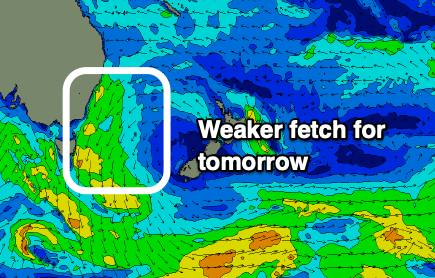 We’ll see the fetch reach maturity early tomorrow morning, resulting in the swell continuing to build through tomorrow, reaching a peak through the middle of the day.
Size wise, north-east magnets should see 3ft+ waves, a touch smaller than was forecast on Wednesday, with smaller options at other beaches. We’ll see conditions improve through the day with a strong N/NW’ly, shifting NW early-mid afternoon, with the S’ly change moving in just before dark.
This is all a touch delayed owing to the front being a touch weaker, hence the size being a little smaller.
 Come Sunday W/SW offshores are due with 2ft fading leftovers, giving into afternoon E/NE tending NE sea breezes.
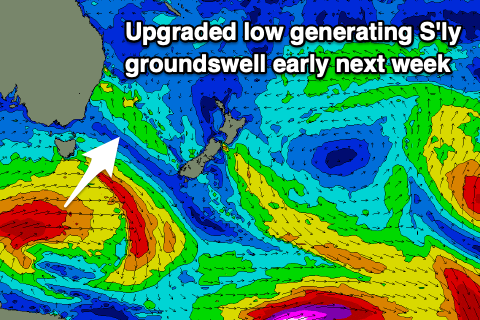
While the N/NE swell has been downgraded a touch we’ve got an upgrade in a new S’ly groundswell due next week, with a stock standard polar front now due to form into a low south-west of the state.
This will project a fetch of gale to severe-gale W/SW winds through our southern swell window Sunday evening and Monday, with the swell filling in Tuesday and reaching 3ft+ across the south swell magnets into the afternoon.
Unfortunately winds look to swing SW to SE in the wake of a front pushing up the coast, linked to the low, with Wednesday possibly looking better with variable tending E/NE winds.
This trough looks to be then absorbed into a broader ridge, geneting building levels of E/NE swell late week, but we’ll have a closer look at this Monday. Have a great weekend!