Nothing major until Tuesday

Eastern Tasmania Surf Forecast by Craig Brokensha (issued Friday 26th February)
Best Days: Tuesday protected spots, Wednesday morning in similar spots
Features of the Forecast (tl;dr)
- Fading NE and S swells tomorrow
- New S'ly swell for Tue with SW tending SE winds, easing Wed with similar winds
Recap
The inconsistent E/NE groundswell seen through the week eased back yesterday, cleanest in northern corners as winds strengthened from the north-western quadrant.
Today our small pulse of flukey NE swell has come in better than expected with, clean, fun 2-3ft surf across the coast. A weak S'ly swell is also on the build this afternoon as a trough moved offshore of us.
This weekend and next week (Feb 27 – Mar 5)
There's no real size or power due from the trough that's moved offshore today with a weak fetch of S'ly winds unlikely to develop much over 2ft+ of leftover and easing S'ly swell tomorrow morning.
There'll also be no real NE energy left in the tank. Winds will be less than favourable for the south magnets and SW tending SE.
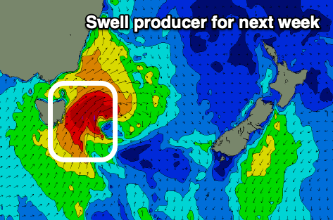 Looking at the S'ly swell due into Tuesday and there's been an upgrade in the expected size with a strengthening cold front pushing across us Monday due to form into a low, resulting in a fetch of strong to near gale-force S/SW winds being generated right off our coast.
This should kick up 4-5ft of S'ly swell Tuesday but with fresh SW tending S'ly winds. The quick movement of the low will result in a decent drop in swell Wednesday, back from 2-3ft or so with similar winds.
Thursday will be cleaner on the south magnets but small and fading.
Longer term we've got more S'ly swell on the cards for Friday and next weekend as a broad polar front pushes up and into the Tasman Sea. Winds look dicey though at the peak, cleaner on the tail end of the swell, but we'll have a closer look at this Monday. Have a great weekend!