Lots of action from the nor-east

Eastern Tasmania Surf Forecast by Craig Brokensha (issued Monday 15th February)
Best Days: Selected locations tomorrow, possibly early Friday, Saturday
Features of the Forecast (tl;dr)
- Small E swell for the coming days
- Building NE tending N/NE windswell Thu and more so Fri with strong N/NE winds, easing slowly Sat with N/NW winds
- E/NE trade-swell from Sun-Tue with a NE groundswell pulse in the mix Tue PM
Recap
A mix of fading swells Saturday back from 1-2ft, but nice and clean, tiny yesterday and today.
This week and weekend (Feb 16 - 21)
We've got a very active forecast period ahead, with a surface trough that's currently sitting off the southern NSW coast due to push north as a ridge of high pressure moves in to the southern Tasman Sea.
Once the ridge moves in we'll see tropical depressions in the Coral Sea squeezing it from the north, setting up a good E'ly trade-fetch, with NE winds extending down to us later week.
 Over the coming days though we'll see small levels of swell developing from E/SE tending E winds falling just within our swell window. No major size is expected with 1-2ft sets due across open beaches tomorrow, coming in around a similar size Wednesday morning ahead of some building E/NE and NE windswell energy late in the day but more so Thursday.
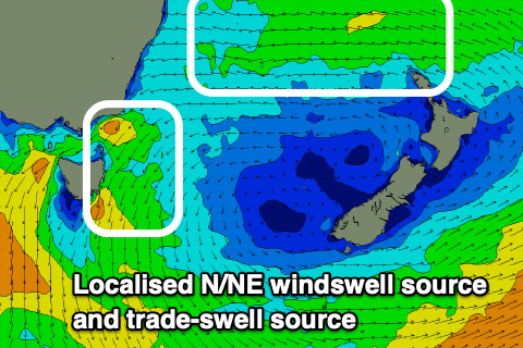
The localised NE windswell will be the most noticeable, generated as a surface trough pushes in from the Bight. Building surf from 2ft to occasionally 3ft Thursday morning to a more consistent 3ft is due late, with Friday seeing stronger 4ft+ sets developing.
Winds however will be onshore over the coming days (variable tomorrow morning) but then strengthening N/NE Wednesday, similar Thursday and strong N tending N/NE on Friday.
 As it'll be a trough moving east, not a proper front, we're not expected to see much in the way of an offshore change Saturday, with winds due to freshen out of the N/NW as the N/NE windswell eases back from 4ft or so. Sunday should see S/SW tending SE winds as the trough finally moves through.
As the N/NE windswell eases though we'll see fun levels of E/NE trade-swell filling in, produced by broad E'ly winds across the top of the high late week and into the weekend. Size wise, the trade-swell should keep open beaches topped up with 3ft+ waves through Sunday and Monday, followed by a NE groundswell on Tuesday.
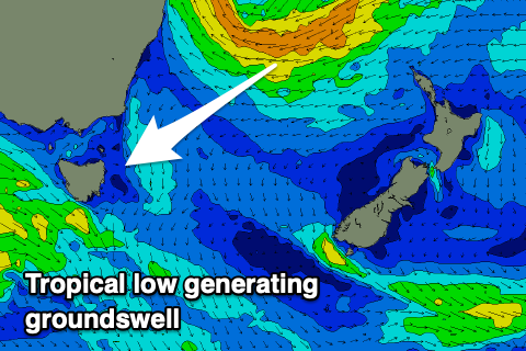
The source of the NE groundswell will be a tropical depression drifting south, off the Queensland coast, falling into the fully developed sea state generated by the trades. A slim fetch of gales looks to be aimed towards us on Sunday, with the swell due to arrive Tuesday and build to 4ft+, though we'll take a closer look at this on Wednesday and Friday.