Upgrade to tomorrow's S'ly groundswell

Eastern Tasmania Surf Forecast by Craig Brokensha (issued Monday 18th January)
Best Days: Tomorrow and Wednesday experienced surfers, Thursday south magnets, Saturday afternoon south magnets
Features of the Forecast (tl;dr)
- Large, powerful S'ly groundswell for tomorrow with fresh SW tending strong S/SE winds, easing slowly Wed with light SW winds ahead of afternoon onshores
- S/SE groundswell in the mix for Wed
- Fun S groundswell building Sat with morning offshores ahead of NE sea breezes
Recap
Tiny surf Saturday but the first in a series of S'ly swell pulses filled in yesterday, with clean 2-3ft waves out of the south, similar today with a secondary pulse of swell.
This week and weekend (Jan 19 - 24)

Upgrade!
The strongest and final storm falling under the spell of the Long Wave Trough (which is currently sitting across the Tasman Sea) has been upgraded in strength and intensity, with it now falling into the classification of a 'bombing low'. This is due to the low dropping over 24hPa of central pressure in 24 hours, and it is doing so right now south of us.
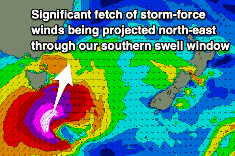 We're seeing a significant fetch of severe-gale to storm-force SW tending S/SW winds projected north-east, through our southern swell window, resulting in a large, powerful S'ly groundswell that's due to peak tomorrow across our region.
The South Arm will be maxing, while on our East Coast, large 6-8ft+ sets are due across our south swell magnets, smaller in protected spots and with a moderate to fresh SW tending stronger S/SE breeze.
The low will actually stall across the entrance to the southern Tasman Sea during tomorrow, helping prolong the swell for our region into Wednesday, while there'll also be some background S/SE groundswell in the mix.
Sets to 4-6ft are still due on the south magnets in the morning, easing back to 3-5ft while tending more S/SE in direction through the afternoon, down steadily from 3-4ft on Thursday.
Winds will improve as the low moves east of our swell window, light W/SW Wednesday morning ahead of varying sea breezes as a small trough sits on our northern region. North of St Helens winds look to go NE, but to the south, winds look to go E/NE, then SE into the afternoon.
Thursday will see favourable W/NW tending N/NE breezes.
Looking at the weekend, and another fun pulse of S'ly groundswell is due from a strengthening polar low, south-west of the state on Friday. A broad fetch of W/SW gales should be projected east-northeast, producing a fun 3ft+ of S'ly groundswell Saturday afternoon with morning offshores and NE sea breezes. We'll confirm this Wednesday.