Average until next week

Eastern Tasmania Surf Forecast by Craig Brokensha (issued Wednesday 30th December)
Best Days: Beaches for the keen Sunday through mid-next week
Features of the Forecast (tl;dr)
- Building NE windswell Sat, easing Sun but with onshore winds
- Small E/SE swell Mon
- Possible building E/NE swell mid-week
Recap
Nothing left after the N/NE swell seen Sunday and Monday, with tiny surf continuing today.
This week and weekend (Dec 31 – Jan 3)
A trough will slide up our coast tomorrow morning, bringing onshore S/SE winds but no major swell. It's when it feeds into an inland surface trough across the south-east of the country that we'll see the swell generating applicabilities starting to develop.
Initially the trough will squeeze a high to the west of the state but this high will move east Friday, into the southern Tasman Sea on Saturday, swinging winds NE through our swell window.
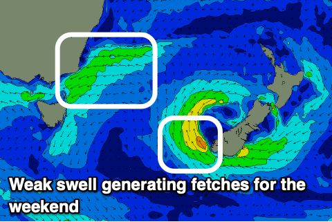 It looks like the trough will sit off the southern NSW coast, with a less than ideal fetch of E/NE winds aimed through our north-eastern swell window, generating a weak NE windswell, likely reaching 3ft on the sets Saturday but with strong NE winds, easing Sunday, back to 2-3ft with weaker NE breezes.
The trough looks to linger in our swell window early next week, with a possible re-intensification on the cards through next Tuesday/Wednesday and possible weak low forming in the Tasman Sea.
There's no major swell potential just yet but open beaches should linger around 2ft Monday and Tuesday, possibly increasing mid-late week but with onshore winds. This isn't ideal but the beaches should be fun for those who aren't fussy.
Also worth noting is a small 2ft+ of E/SE swell Monday from a fetch of weak winds off New Zealand's South Island.
More on all of this in Friday's update though.