Weak swells this week, more potential next week

Eastern Tasmania Surf Forecast by Craig Brokensha (issued Monday 28th December)
Best Days: No good days
Features of the Forecast (tl;dr)
- Fading N/NE swell, clean most of tomorrow
- Weak S/SE tending E and the NE windswell Thu PM through Sat
- Possible better E/NE swell Mon/Tue
Recap
Small, clean waves Saturday morning, while a chunky new N/NE windswell developed through yesterday with 3-4ft waves in the morning, bigger through the afternoon but with strong winds. Northern corners were cleanest.
Today winds swung around to the south and the swell was on the ease from 3ft to occasionally 4ft.
This week and weekend (Dec 29 – Jan 3)
The N/NE swell will ease off this afternoon and further tomorrow with the swell generating fetch retreating away from our swell window. Leftover 1-2ft waves are expected with a morning W/NW breeze, possibly holding from the NW into the afternoon.
The next source of swell will be a weak surface trough moving up our coast on Thursday, though a localised fetch of strong S/SE winds isn't expected to generate any size or quality.
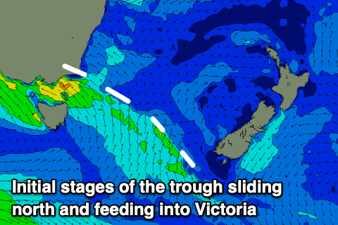 The trough will feed into a broader inland trough developing across Victoria, and we'll see this dip back south-west, west of the state on the weekend, swinging winds E and then NE across our region.
Weak levels of S/SE tending E and then NE windswell are due, though not really above 2ft+ and with onshore S/SE winds Thursday, E/SE winds Friday and E/NE winds Saturday.
Come Sunday the trough will deepen, and winds should strengthen a little while extending in length, likely generating building levels of E/NE swell through Sunday afternoon and Monday, peaking Tuesday morning as a low develops and the trough drifts south-east.
Size wise, the models are still a little divergent but we should see surf in the 3-4ft range at its peak, though we'll confirm this Wednesday.