More active period ahead out of the south

Eastern Tasmania Surf Forecast by Craig Brokensha (issued Wednesday 23rd September)
Best Days: Tomorrow, Friday morning south swell magnets, Sunday, Monday, Tuesday, Wednesday
Recap
Fun, easing N/NE windswell from 2-3ft yesterday cleanest across open beaches and northern ends, tiny today and still bumpy at the north magnets.
This week and weekend (Sep 24 - 27)
There's been a slight upgrade in swell due in the wake of a trough sliding up past our coast tomorrow.
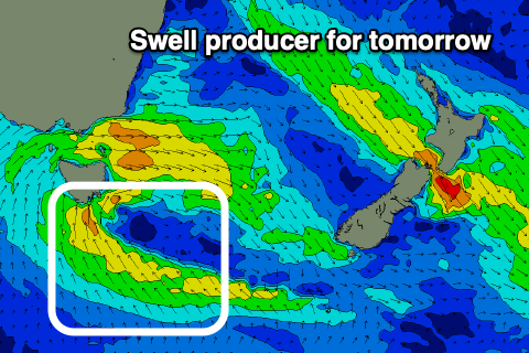 A fetch of weakening S/SE winds will project north through our swell window, with a new S/SE swell to 3ft due across open beaches and winds are also looking favourable. A morning W/SW breeze is due to tend variable ahead of NE sea breezes, favouring northern corners from late morning.
The swell is likely to ease through the day, dropping further from a small 1-2ft Friday with W/NW tending NE winds.
Moving into the weekend and our new S'ly swell is still on track, with a broad and strengthening polar front due to project up and across us, into the Tasman Sea on Saturday.
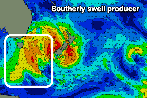 A fetch of strong S/SW winds on Saturday should kick up a late increase in size to possibly 2-3ft on the south magnets, but Sunday looks much better for size with surf to a good 4ft.
The easing trend will be slowed by another weaker front moving in on the tail of this progression, keeping 3ft+ sets hitting the south magnets Monday morning, followed by a possible reinforcing S/SE groundswell Wednesday. This will be from the formation of a deep low south of New Zealand Sunday, but more on this Friday.
With the S'ly swell pulses, winds Sunday look to improve, swinging from fresh SW to possibly variable into the afternoon and then W/NW tending NE on Monday.