South followed by north

Eastern Tasmania Surf Forecast by Craig Brokensha (issued Friday 18th September)
Best Days: Northern corners tomorrow and Sunday, Monday and Tuesday open beaches
Recap
A small increase in S'ly windswell yesterday with OK conditions for the desperate, small and clean again today.
This weekend and next week (Sep 19 - 25)
There's been no change to the strong S'ly groundswell due across the state tomorrow with it due to kick later today but peak tomorrow morning to a good 3-4ft across the south swell magnets, easing into the afternoon and further Sunday.
Mixed in with the S'ly groundswell we'll see a building N/NE windswell event across the coast as a slow moving mid-latitude low moves in across South Australia and then Victoria, squeezing a strong high in the Tasman Sea.
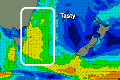 This will see strengthening and broadening N/NE winds aimed down into us, producing a building N/NE windswell to 3ft or so later tomorrow, and a bigger 4ft+ through Sunday (into the afternoon.
A front pushing across us Sunday evening will see the swell generating fetch push away from us, with the N/NE windswell then easing from 3ft to possibly 4ft, fading from 2ft Tuesday.
Looking at the local winds and strengthening NE breezes are due tomorrow (possibly variable early) so hit those northern corners with the S'ly groundswell, and Sunday will see strong N-N/NE winds persisting all day.
N/NW breezes are due to kick in Monday, similar Tuesday and stronger, so those north-east magnets won't be great and open, east facing beaches will be better.
Longer term there's nothing too significant on the cards, with a weak polar front pushing up and past us possibly generating a S'ly swell late week and into next weekend, but more on this Monday. Have a great weekend!