Small southerly swells

Eastern Tasmanian Australia Surf Forecast by Craig Brokensha (issued Friday 11th September)
Best Days: South magnets Tuesday through Thursday
Recap
Tiny surf yesterday, a choppy 1-2ft of N/NE windswell today.
This weekend and next week (Sep 12 - 18)
The weekend looks flukey swell wise, with the N/NE windswell from today expected to drop from 1-1.5ft tomorrow, while our tricky S’ly groundswell pulse for the afternoon is just that.
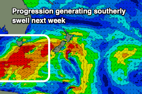
A very strong low has formed west-southwest of the state and will drop south-east into our swell window today.
 The alignment is looking a bit too zonal now and the size limited for our south swell magnets. We’ll be lucky to see 2ft sets on the south magnets later tomorrow, fading Sunday from 1-2ft.
Winds look dicey tomorrow in any case, swinging S’ly just after dawn and SE into the afternoon. Sunday will be cleaner with a N/NW tending NW breeze.
Our S’ly groundswell for mid-next week is more reliable with a broad and significant frontal progression expected to push under us and into the Tasman Sea on Monday, followed by a possible secondary system Tuesday.
The alignment of these systems isn’t too amazing but the breadth and strength of winds should produce fun pulses of S’ly groundswell for Tuesday through Thursday.
Tuesday’s first pulse should offer 2-3ft waves across south swell magnets, with Wednesday morning possibly being a touch better and to 3ft+. The swell is then due to ease, dropping back from 2ft or so Thursday.
Winds look great with N/NW tending variable breeze Tuesday, N/NW all day Wednesday and then N/NW ahead of a shallow change Thursday. Longer term there’s nothing too significant on the cards, but more on this Monday. Have a great weekend!