New southerly swells from next week

Eastern Tasmania Surf Forecast by Craig Brokensha (issued Friday 3rd April)
Best Days: Tuesday morning, Wednesday morning
Recap
A building onshore NE windswell yesterday, improving late in the day but best today and to the expected 3-4ft on Monday, not the downgraded advice on Wednesday to 2-3ft.
The swell should have eased through the day as the low responsible kept tracking south-east.
This weekend and next week (Apr 4 - 10)
We'll see the swell from today dropping back from a much smaller 1-2ft if we're lucky tomorrow morning, most likely tiny. This will be a result as the swell generating low drifting south-east and away from us last night.
Following this there's some new S/SW swell due into early next week as a mid-latitude low moving in from the west on the weekend draws in a polar front and fetch of gale to severe-gale S/SW winds through our southern swell window on Sunday evening.
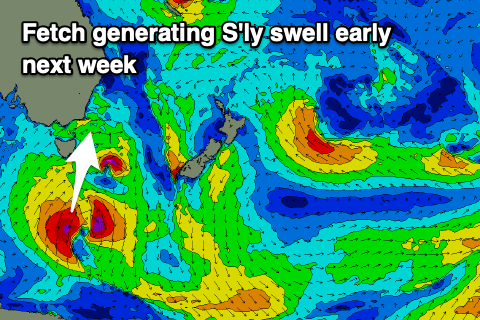 A front associated with this storm will push across us Monday but no swell is expected until overnight with Tuesday seeing a good kick in size to 4-5ft across south facing beaches with favourable W/SW morning winds, E'ly into the afternoon.
The swell will ease slowly Wednesday with morning offshores, small to tiny into Thursday.
Longer term a strong and significant node of the Long Wave Trough developing across New Zealand will project a series of strengthening polar fronts from under us into the Tasman Sea, producing plenty of swell from later in the week and more so next weekend. More on this Monday though. Have a great weekend!