New swell late week

Eastern Tasmania Surf Forecast by Craig Brokensha (issued Monday 30th March)
Best Days: Friday
Recap
A building N/NE windswell through Saturday, best yesterday with the swell kicking further through the day to 3-4ft on the north-east magnets with cleaner conditions in northern corners, but smaller surf.
Today the swell was cleaner and easing back from 3-4ft.
This week and weekend (Mar 31 – Apr 5)
Any NE swell seen today will be all but gone tomorrow with the swell generating fetch moving out of our swell window yesterday, leaving fading 1-1.5ft sets max tomorrow.
Conditions will be clean in the morning ahead of sea breezes, similar Wednesday with tiny, clean conditions in the morning.
 Our next surfable swell will again arrive from the north-east and there's been an upgrade in the size from late last week.
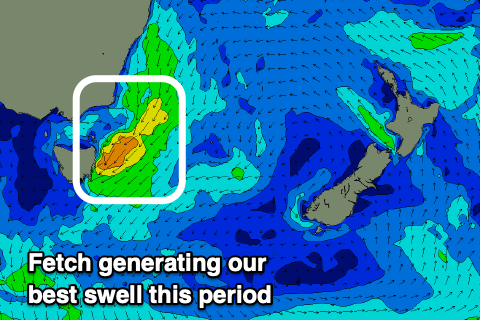
An inland low is forecast to dip south-east across us and offshore Thursday, with a good fetch of strong to gale-force NE winds due to be directed through our north-eastern swell window.
The fetch will develop Thursday kicking up an afternoon increase in weak windswell with onshore winds to 2-3ft later in the day, with the fetch strongest overnight before slipping out of our swell window.
A good kick Friday morning to 3-4ft is expected out of the E/NE as winds shift W/NW and then N/NW into the afternoon as the swell eases.
Following this there's chances for a S'ly swell early next week as a broad and weakening mid-latitude moves in from the west. More on this Wednesday though.