Strong but acute S'ly swells on the way

Eastern Tasmania Surf Forecast by Craig Brokensha (issued Wednesday 18th March)
Best Days: Friday, early Saturday, Sunday morning, Monday, Tuesday
Recap
Easing swell yesterday from 1-2ft, poor today with choppy and small to tiny amounts of swell.
This week and next (Mar 19 - 27)
A small background E'ly swell to 1-2ft should continue across the coast tomorrow with light morning offshore winds and afternoon sea breezes.
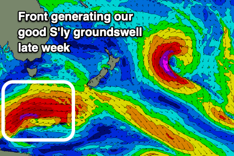
We've got better pulses of S'ly groundswell due from Friday though with a strengthening polar front currently projecting east-northeast below the state while generating a great fetch of gale to severe-gale W/SW winds.
We should see a strong S'ly groundswell from this front, filling in Friday and peaking from the middle of the day with sets to 4ft+ across south swell magnets along with all day offshore NW-N/NW winds.
 A change will move through Saturday with SW tending SE winds, E/NE later in the day with the S'ly groundswell from Friday easing from 3ft to possibly 4ft, mixed in with some mid-period S'ly swell from the change,
A low point in swell is likely Sunday morning but we've got a good new S'ly groundswell due to fill in through the day, generated by a more distant but stronger polar low firing up south-west of the state late week.
A fetch of severe-gale to storm-force W/SW winds will be produced just in our southern swell window, with inconsistent and diffracted sets pushing in to 3ft to possibly 4ft on the south swell magnets into the afternoon but with a SW tending SE breeze.
Monday looks better as the swell eases with W/SW tending SE and then NE winds.
A couple of small reinforcing pulses of swell are likely Tuesday to 2-3ft but otherwise we'll be looking at some fun E/NE trade-swell later next week. More on this Friday.