Get stuck into the easing swell

Eastern Tasmania Surf Forecast by Craig Brokensha (issued Monday 9th March)
Best Days: Tomorrow, Wednesday morning
Recap
Fun and clean, easing waves from 2-3ft on Saturday, hanging in there Sunday with OK conditions for the keen.
Today our building E/SE swell from the remnants of Tropical Cyclone Esther has come in at a good 3-4ft this morning, with sets to 5ft due this afternoon as it peaks.
This week and weekend (Mar 10 - 15)
While today we've seen the strongest pulse of E/SE swell from ex-Tropical Cyclone Esther filling in, there's still plenty of surf due tomorrow and Wednesday as the swell slowly eases.
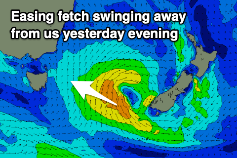 We saw a great fetch of strong to gale-force SE winds hanging in through our swell window yesterday afternoon, weakening into the evening and then shifting away and more towards New Zealand.
This will result in a steady drop in size, easing from 3-4ft+ on the sets tomorrow morning, down from a smaller 2ft or so on Wednesday.
The mornings will be cleanest with offshore winds, giving into NE sea breezes both days.
Later week some small and weak N/NE windswell is expected across north-east swell magnets from a weak fetch of N/NE winds through our swell window Thursday, though only to 1-2ft later in the day and Friday morning.
NW offshores will give into a S'ly change Friday but with the lack of swell, it's not looking great. Make the most of tomorrow.
The change will strengthen overnight kicking up a weak windswell for Saturday but with poor winds.
Longer term a strong ridge building across the Tasman Sea and squeezed by a tropical cyclone drifting south-east from the Queensland coast will generate some small E'ly swell early next week with potential for more size beyond, but we'll keep a close eye on this.