Large, upgraded NE swell inbound

Eastern Tasmania Surf Forecast by Craig Brokensha (issued Wednesday 4th March)
Best Days: Tomorrow afternoon northern corners, Friday southern corners
Recap
Small, easing 1-2ft waves yesterday, while today we've got a new S'ly groundswell, coming in at 2-3ft with offshore winds.
This week and weekend (Mar 5 - 8)
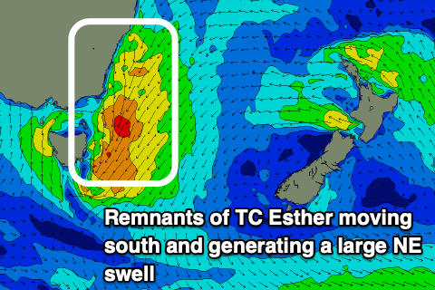
Today's good pulse of S'ly groundswell is expected to ease through tomorrow, but it'll be replaced by a building NE windswell which is due to get large into the afternoon while strengthening to mid-period energy, with an upgrade in size from Monday.
The source of this swell is the remnants of Tropical Cyclone Esther, drifting down across NSW and Victoria while squeezing a high to the west.
We should see a great fetch of strong NE winds broadening and drawing out through our swell window tomorrow as a low pressure centre forms, with the low dropping south-east off the coast into the evening and Friday morning.
 We're now expected to see north-east facing beaches building rapidly tomorrow from 2-3ft during the morning, upwards to 6ft+ by dark.
Conditions are looking poor with strong onshore E/NE tending N/NE winds through the morning and early afternoon, shifting N/NW mid-late afternoon and into the evening. With this try northern corners into the afternoon as the swell kicks in size.
Friday looks excellent with the return S/SW tending S/SE flow form the backside of the low favouring southern corners as the swell eases steadily from 4-6ft at north-east magnets at dawn.
Come Saturday there isn't expected to be any real NE swell left, with a mid-period S'ly swell from strong S/SW winds on the western flank of the low.
S/SW tending S/SE winds will create average conditions at spots seeing the 3ft or so of swell, easing Sunday as onshore winds persist.
Longer term there's nothing too major on the cards so make the most of the coming NE swell event.