Good south followed by north-east

Eastern Tasmania Surf Forecast by Craig Brokensha (issued Monday 2nd March)
Best Days: Wednesday south magnets, Thursday afternoon, Friday morning north-east swell magnets
Recap
Tricky pulses of diffracted S'ly groundswell with Saturday reported as flat, while Sunday reported a kick in size to 2-3ft but more from the east than south.
Today the surf was smaller and average with onshore winds.
This week and weekend (Mar 3 - 8)
Any swell seen today is expected to be gone tomorrow, but we've got an upgrade in the S'ly swell event later tomorrow but more so Wednesday.
Currently a strong polar front is projecting up and towards the state, from the south-west and through our southern swell window. It's generating a stronger fetch of SW gales compared to forecasts on Friday resulting in an upgrade in the expected size.
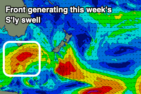 The front will project nicely up past the south-east corner of the state this evening and tomorrow morning, generating a good S'ly groundswell for Wednesday morning. Through tomorrow we should see an increase in mid-period S'ly swell through the day but with W/SW tending onshore SE winds.
Wednesday is the pick as the S'ly groundswell peaks, offering sets to a good 4ft+ or so on the south swell magnets, easing through the day.
Winds should be variable and light N/NW early, but shifting E/NE-NE through the day, so stick to protected northern corners.
The swell will be easing from 2ft+ or so Thursday along with onshore E/NE winds and a building NE windswell as a strong high slipping in behind the polar front is squeezed by a deepening inland surface trough.
Strengthening NE winds will be generated through our swell window Wednesday afternoon and more so Thursday, with the swell becoming moderate to large our of the NE, easing slowly Friday as a low forms and the fetch of NE winds takes its time to leave our swell window.
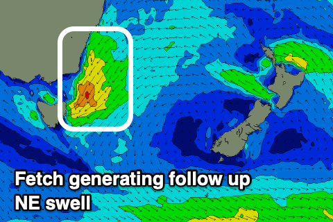 Onshore building surf to 2ft+ is due later Wednesday, with Thursday likely to build to 4-6ft across the north-east magnets through the afternoon. As the low develops on Thursday we're expected to see winds shift E to S/SW, favouring those north-east magnets and creating great waves into the afternoon.
SW tending SE winds will again favour southern corners as the NE swell eases from 3-4ft.
Moving into the weekend and some weak S'ly windswell is due from the backside of the low Saturday, fading Sunday with poor winds with nothing of significance thereafter.
So make the most of the coming week!