Fun N/NE swell for the weekend, followed by swell from the east next week

Eastern Tasmania Surf Forecast by Craig Brokensha (issued Wednesday 29th January)
Best Days: Late Saturday north-east swell magnets and early Sunday, Tuesday morning onwards next week
Recap
Near flat yesterday and with a tiny SE swell showing today.
This week and next weekend (Jan 30 – Feb 2)
A tiny hint of SE swell is likely to persist tomorrow across open beaches but without any real surfable size.
Moving into the weekend the small and flukey N/NE swell mentioned on Monday looks a little better with the fetch of N/NE winds off the southern NSW coast due to push further down the coast and towards us Friday evening and Saturday morning.
 A fun pulse of N/NE swell should filter down Saturday, peaking later in the day to 3ft across north-east swell magnets, easing back from 2ft to possibly 3ft Sunday morning.
Local winds are still favourable with a fresh NW'ly Saturday morning, shifting S/SE late afternoon/early evening. Sunday looks tricky with early S winds, shifting more W/NW through the day.
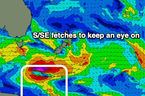
Moving into next week and we've got a few swell sources on the cards. The strongest being a prolonged S/SE swell event, generated by an anchored fetch of strong to gale-force S/SE winds through our swell window, south of New Zealand from tomorrow afternoon and evening through Monday.
It'll have various ebbs and flows, with inconsistent amounts of S/SE swell due to arrive later Monday but fill in more so Tuesday through Wednesday.
Building sets are expected Tuesday afternoon to 3ft+, peaking Wednesday to 3ft to possibly 4ft and then easing slowly from Thursday.
At the same time a weak low forming off the southern NSW coast is expected to generate a fetch of E/SE winds in our north-eastern swell window, generating fun levels of E/NE swell. More on this in Friday's update though.