Small, average swells form the south-east to north-east

Eastern Tasmania Surf Forecast by Craig Brokensha (issued Friday 17th January)
Best Days: Sunday morning desperate surfers, Tuesday and Wednesday mornings
Recap
More size than expected out of the E/NE yesterday and with favourable winds, while less size than expected today out of the S'th with the trough moving off our coast.
This weekend and next week (Jan 18 - 24)
While today's reported size wasn't too significant we've got a better pulse of S/SE swell for tomorrow, generated by a good fetch of S/SE winds feeding into the trough that's currently sitting east of us.
The trough is expected to weaken but winds will unfortunately linger onshore out of the S/SE-SE. The swell looks to come in around 2ft+, easing Sunday from a small 2ft with slightly better S/SW tending SE winds.
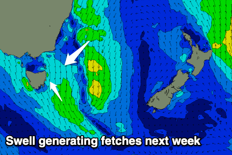 Moving into next week and another surface trough that was forecast to deepen more significantly off our coast is now looking a bit weaker and the swell potential has been pulled back.
A fetch of strengthening S/SE winds are due to form off our coast Monday kicking up a weak S/SE windswell, reaching 2-3ft into Tuesday afternoon. Also in the mix will be some E/NE-NE swell from trade-winds across New Zealand yesterday and today, and then an additional infeed of strong NE winds on the eastern flank of the trough.
Size wise we're not looking at anything over 2-3ft with SW to SE winds on Tuesday and W tending NE winds Wednesday.
Longer term we may see a better NE windswell event later week as a broad mid-latitude low moves in from the west, but we'll have a closer look at this Monday. Have a great weekend!