Easing E/NE swell followed by extended S/SE

Eastern Tasmania Surf Forecast by Craig Brokensha (issued Wednesday 15th January)
Best Days: Southern corners tomorrow and Friday, next Monday afternoon onwards
Recap
Some fun S'ly swell left in the mix yesterday, easing from 2-3ft, but with average conditions, cleanest in southern corners as a small N/NE swell built.
Today the N/NE swell is back to 1-2ft with average conditions.
This week and weekend (Jan 16 - 19)
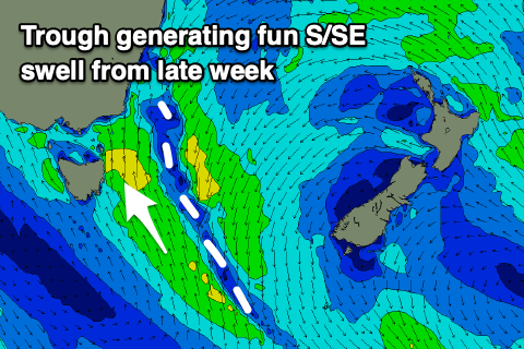
A surface trough that's slowly moving in from the west is generating a weak fetch of NE winds, aimed at us.
The fetch will remain weak but aimed towards us today, drifting slowly east tomorrow as the trough moves in.
 This should see a fun 2ft+ of E/NE swell across the coast tomorrow morning, easing through the day and a variable wind at dawn will give into a strong S'ly change mid-morning, favouring southern corners.
A good increase in S/SE windswell is now expected off this trough, with it moving slowly east while aiming an elongated fetch of S/SE winds in our swell window.
Friday should see 3ft to occasionally 4ft waves but winds will be only favourable for protected spots, strong out of the S/SW early, shifting S/SE through the day.
Unfortunately S/SE-SE winds look to create average conditions Saturday as the swell eases and swings more SE, dropping from 3ft on the sets.
Sunday doesn't look any better with a low point in swell and strengthen S/SE winds as another surface trough starts to deepen east of us. This looks to be more substantial and with this, the swell a bit bigger early next week. Winds also look to become more favourable on the backside of the swell event, but check back here Friday for more on this and a possible infeef of NE swell as the S/SE swell eases.