Tricky winds and swells to work around

Eastern Tasmania Surf Forecast by Craig Brokensha (issued Monday 13th January)
Best Days: Late tomorrow south swell magnets, Thursday morning southern corners
Recap
Not much NE swell left into Saturday with it dropping back right overnight, but the S'ly groundswell event through Sunday and today has provided great waves across the coast.
The 'bombing low' has generated moderate to large pulses of S'ly groundswell with favourable winds.
This week and weekend (Jan 14 - 19)
One final pulse of reinforcing S'ly swell is due tomorrow across our south swell magnets, generated on the backside of the 'bombing low' linked to the last two days of swell.
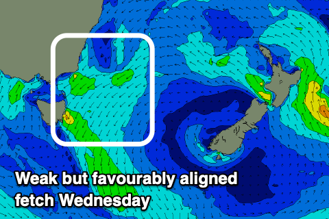
Fun sets to 3ft are due across the south swell magnets, if not for the odd bigger one, easing from 2ft Wednesday.
 Winds are a little funky, increasing out of the S'th from dawn and then swinging onshore and NE later in the day. Therefore try the south swell magnets later in the day.
A small N/NE windswell is likely to be in the mix as well tomorrow but only to 1-2ft, a bit bigger and to 2ft+ on Wednesday but with moderate to fresh N/NE winds.
Thursday looks fun though as a trough brings a S'ly change through the morning along with easing sets out of the N/NE from 2ft+.
The trough will generate some weak S/SE windswell later in the day and for Friday but with poor and onshore winds, easing into the weekend with no real improvement in the local winds.
Longer term another trough deepening off the coast may generate a more significant S/SE windswell early next week followed by NE swell, but more on this Wednesday.