Plenty of swell to sift through from all directions

Eastern Tasmania Surf Forecast by Craig Brokensha (issued Monday 30th December)
Best Days: Tomorrow morning southern corners, Wednesday morning, Thursday morning, Saturday afternoon, possibly south swell magnets Sunday afternoon
Recap
A fun 2-3ft of N/NE swell Saturday, cleanest into the evening with a shallow change, back to 1-2ft on Sunday for the keen beans. Today is a small 1-2ft again and not great.
This week and weekend (Dec 31 - Jan 4)
The N/NE swell should kick up a bit more in size and power tomorrow as a fetch of N/NE winds develop off the southern NSW coast and extend to just north of us.
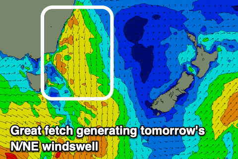 A good spike in size to 3ft+ is expected through tomorrow, easing off late in the day. Looking at the local winds and the early will be best in southern corners with a fresh S/SE-SE breeze, swinging more N/NE through the day. Up the north of the coast we may see winds go offshore again late, but the early is the go.
Come Wednesday a smaller 2ft wave is expected with W/NW tending NE winds.
As the N/NE windswell fades, we then look to the inconsistent NE groundswell due from Tropical Cyclone Sarai.
TC Sarai moved into our swell window over the weekend, with an off centre fetch of E'ly gales generated just within it, south of Fiji.
 Sarai is expected to slowly weaken but move only slightly east today, before breaking down tomorrow and shifting away from our swell window.
With a travel time of three days or so, we should see some very inconsistent NE groundswell on the coast from Sarai arriving Thursday and offering very inconsistent 2ft to possibly 3ft sets across swell magnets, easing from a similar size Friday morning.
Keep your expectations low for this swell event and aim for the mornings when winds will be offshore ahead of ahead of NE sea breezes.
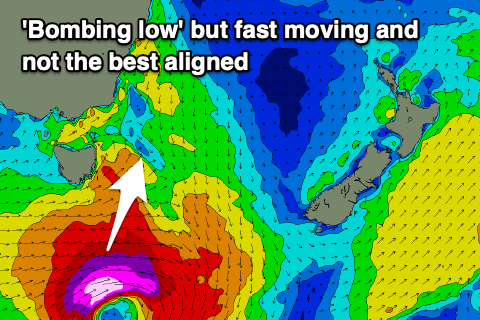
Another good pulse of N/NE windswell is due on the weekend as the swell from TC Sarai fades, followed by a flukey S'ly groundswell Sunday.
This will be linked to a 'bombing low' forming south-east of us on Saturday, with the northern flank squeezing a high and generating a fetch of strong N/NE winds in our swell window Saturday morning, kicking up 3ft of swell through the day along with N'ly winds ahead of a strong afternoon S'ly change, great for southern corners.
This change will be linked to the low moving into our swell window, with a quick burst of gale to severe-gale W/SW winds due to be generated.
This isn't ideal for swell generation, but the strength of the low may overcome this with a slight spike in S'ly groundswell possible to 2-3ft at south swell magnets but with a S tending NE breeze. More on this Wednesday. Have a happy and safe New Year!