Swell showing from late week but more so into next week

Eastern Tasmania Surf Forecast by Craig Brokensha (issued Monday 16th December)
Best Days: Saturday morning, protected south swell magnets early next week
Recap
No swell on the weekend and tiny today.
This week and weekend (Dec 17 - 22)
The coming week remains void of any surfable swell until later Friday and more so Saturday and that's in the form of a small N/NE windswell.
A 'bombing low' will form south-west of the state on Friday with it dropping rapidly in central pressure, down 24hPa in less than 24 hours.
As this low deepens, it will squeeze a strong high in the Tasman Sea, with an elongated fetch of strong N/NE winds developing through Friday afternoon and into the evening.
 A late kick in size to 2ft+ is due on Friday, with the swell easing rapidly Sunday from a similar size under offshore W'ly winds.
Now, the low itself will initially be quite zonal in alignment through our swell window but as it moves slowly east into Sunday we'll see a great fetch of W/SW gales aimed through our southern swell window.
This should produce a good S'ly groundswell for later Monday and more so Tuesday, coming in around 3-5ft across south swell magnets if everything goes to plan.
Winds could be an issue though with onshore E'ly breezes possibly both Monday and Tuesday, though we'll review this Wednesday.
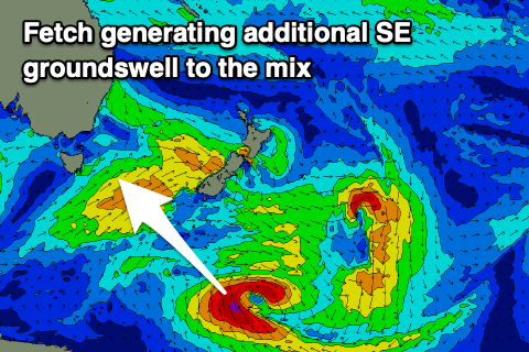
There'll also likely be a SE groundswell in the mix, generated by a fetch of S/SE gales wrapping around the southern flank of a broad low south-east of New Zealand. The size of this looks to be 3-4ft, but we'll also confirm this Wednesday.