One day of small waves, three more with a stack of wind

Eastern Tasmania Surf Forecast by Ben Matson (issued Monday 14th October)
Best Days: Thurs: small E/NE swell with good winds. Sun: small/mod windy south swell, easing, abating and improving Mon.
Recap: A solid E’ly swell built Saturday, then eased from Sunday and is now continuing to abate in size.
This week (Oct 14 - 17)
These notes will be brief as Craig’s on annual leave.
Having not looked at a synoptic map in the last week, I’m just getting back up to speed with things.
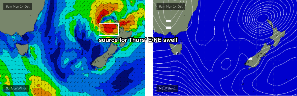
The charts show a low pressure system in the northern Tasman Sea, which is aimed away from our region though a small E’ly fetch on its southern flank is generating some E/NE swell for Southern NSW. Its potential is being tempered by a quick SE track; it’s expected to stall off the NW tip of New Zealand today, so most of this fetch probably won’t generate any energy for our region.
However, a strong E'ly tending E/SE fetch will develop off the west coast of the North Island today, holding into tomorrow morning (see below), and this will kick up a fun small E/NE swell for Eastern Tasmania. The leading edge is due very late Wednesday, probably overnight, and Thursday is your bet for the most size and energy.
For some reason the models don’t seem to like this swell much at all, and are expecting a peak on Thursday around 0.6m at just over ten seconds, translating this to 1-2ft surf for Thursday. I think we’re looking at much better surf prospects, up into the 2-3ft range at times by the afternoon (smaller early morning), and conditions will be clean with mainly offshore winds.
Prior to this, expect small residual energy through Tuesday and Wednesday with variable conditions - probably offshore Tuesday but freshening N’ly Wednesday.
A freshening N/NE breeze off the NSW during Tuesday may kick up some small N/NE short range energy for Thursday, but I’m not expecting much in it. Slightly stronger winds are expected in this swell window region on Wednesday but it won’t last long so I’m keeping my expectations low for any major N/NE swell to finish the working week.
As it is, Friday will see gale force NW winds as a series of powerful fronts sweep across the state. So, make the most of Thursday’s small swell and clean conditions.
This weekend (Oct 18 - 19)
Tiny surf and westerly gales are expected Saturday as more vigorous frontal systems cross the state.
These systems will finally track into our south swell window around the same time, generating a flukey S’ly swell for Sunday with a wide variety of size - up to 3-4ft at reliable south swell magnets and exposed northern ends, but likely to remain tiny elsewhere. Winds will remain strong W/NW too so it’ll be blustery in the lineup. Not recommended at this stage.
Next week (Oct 20 onwards)
A final S’ly swell in this sequence will maintain similar energy into Monday from Sunday (3ft south swell magnets, tiny elsewhere), but otherwise we’re looking at another spell of tiny waves through the middle of next week.
More on this in Wednesday’s update.
Comments
Thanks Ben.