Make the most of the easing east swell

Eastern Tasmania Surf Forecast by Craig Brokensha (issued Wednesday 11th September)
Best Days: Tomorrow morning
Recap
Fun easing mix of swells from 2-3ft yesterday morning, while today a mix of inconsistent S'ly groundswell and afternoon building E'ly swell is showing on the coast.
Today’s Forecaster Notes are brought to you by Rip Curl
This week and weekend (Sep 12 - 15)
This afternoon's increase in E'ly swell should hopefully hit 3ft, easing back tomorrow from the 2-3ft range across open beaches, flat Friday.
Winds tomorrow will be offshore in the morning from the NW, tending W/NW ahead of a late SE change.
 This change will be linked to a front clipping the corner of the state, bringing no real increase in swell Friday (1-2ft S'ly windswell).
A similar front is then expected Friday evening, with a similar weak 1-2ft of S'ly windswell Saturday, with better swell prospects into next week.
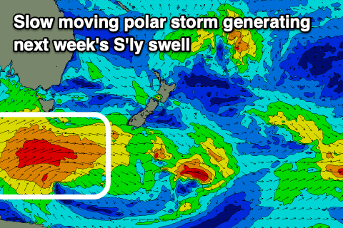
A strong and slow moving polar low is forecast to form south-west of the state on the weekend, projecting a fetch of W/SW gales through our southern swell window, producing a small S'ly groundswell for Monday and better sized swell Tuesday.
Monday looks minimal and only to 2ft across south magnets, with Tuesday seeing better 3-5ft sets with offshore winds.
Following this we may see a N/NE windswell event later in the week, but more on this Friday.