Good run of swell from the north-east

Eastern Tasmania Surf Forecast by Craig Brokensha (issued Monday 2nd September)
Best Days: Tuesday, Wednesday, Thursday morning
Recap
Friday's S'ly swell dropped right away into Saturday leaving tiny surf, similar Sunday.
Today a small NE swell is showing to 1-2ft across the magnets with clean conditions.
Today’s Forecaster Notes are brought to you by Rip Curl
This week and weekend (Sep 3 - 8)
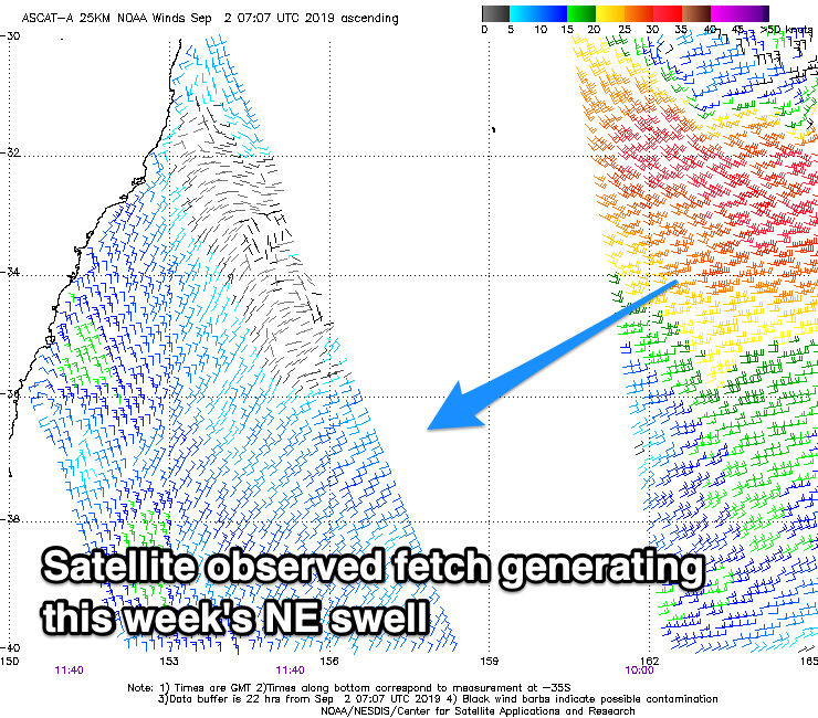
Our NE swell event for this week has been upgraded a little in size and prolonged in activity owing to the low generating it south of New Caledonia drifting south and stalling in the Tasman Sea tomorrow, just off New Zealand's West Coast.
Over the weekend the low generated a great fetch of strong to gale-force E/NE winds through our north-eastern swell window, producing tomorrow's kick in swell.
 North-east facing beaches should build to 3ft on the sets through the afternoon tomorrow, easing slowly from a similar size Wednesday morning under N/NW winds tomorrow (tending N/NE through the afternoon in some regions) and all day NW on Wednesday.
The low is slowly moving south into the Tasman Sea and will generate an additional fetch of strong E/NE winds more in our eastern swell window tomorrow, producing a reinforcing pulse of E/NE swell for Wednesday afternoon and Thursday morning to 2-3ft.
Conditions will be best through the morning with a light W/SW offshore, giving into afternoon sea breezes.
The swell will drop rapidly into Friday but conditions will turn for the worse as a deep mid-latitude low moves in from the west. The models are still struggling the speed and timing of this low, but in any case it looks like we'll see a fetch of gale-force E'ly winds developing off the southern NSW coast, generating a mix of onshore windswell Friday afternoon and possible NE swell Saturday morning.
We'll have a closer look at this on Wednesday though.