Flukey weekend, more reliable swells next week

Eastern Tasmania Surf Forecast by Craig Brokensha (issued Wednesday 7th August)
Best Days: Monday onwards
Recap
A new S/SE groundswell was expected on the coast yesterday, but with the South Arm only reported at 2ft+, it probably didn't reach the expected 3-5ft on the East Coast.
The swell has faded into today leaving tiny clean waves.
Today’s Forecaster Notes are brought to you by Rip Curl
This week and weekend (Aug 8 - 11)
Tomorrow will be mostly tiny but we may see a hint of small S/SE swell into the afternoon, offering the odd 2ft'er across south magnets. Winds are looking better through the morning now and light W/NW, holding into the afternoon.
The dynamics surrounding the deepening low moving across the state and off the coast Friday has changed a little, with no significant size now due until Saturday when a fetch of strong to gale-force S/SW winds are generated just within our southerly swell window, to our south-east early in the morning.
 This looks to generate a building S'ly swell for Saturday, reaching 2-3ft across south swell magnets into the afternoon along with persistent W/SW winds (not great but OK).
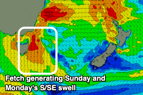
Moving into Sunday we'll see the low strengthen with a fetch of strong S/SE winds forecast to be projected up past our coast into the afternoon, kicking up a rapid kick in S/SE swell later in the day.
South facing beaches should reach a messy 4ft by dark but with strong S'ly winds. Monday will be much better with offshore SW tending W'ly winds and easing S/SE swell from 4ft.
This will be replaced by a strong new S'ly groundswell on Tuesday/Wednesday, generated by a vigorous polar frontal system projecting a fetch of strong to gale-force S/SW winds up on the edge of our southern swell window Monday.
We'll likely see this swell building Tuesday, peaking into the afternoon around 3-5ft at south facing beaches, easing from the 4ft range Wednesday. Winds on Tuesday morning will be good and offshore from the W/NW but sea breezey into the afternoon and then all day out of the NW Wednesday.
More on this dynamic and changing setup Friday.