Nothing of significance until next week

Eastern Tasmania Surf Forecast by Craig Brokensha (issued Wednesday 24th July)
Best Days: Wednesday onwards next week
Recap
Unsurfable the last two days and more of it to come.
Today’s Forecaster Notes are brought to you by Rip Curl
This week and weekend (Jul 25 - 28)
Unfortunately there's still no significant surf on the cards for our coast until early next week (the small E swell for the weekend now looks tiny) with a surface trough moving in from the west due to slide up past us Monday evening.
 A fetch of strong to possibly gale-force S/SE winds are forecast to be generated in our southern and south-eastern swell windows, kicking up a moderate sized pulse of S/SE swell Tuesday, easing from the SE Wednesday.
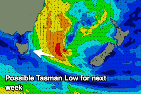
The latest GFS update as a Tasman Low forming resulting in a more prolonged and strengthened E/SE swell event into the end of the week (we'll have to keep an eye on this).
Size wise, Tuesday looks to build to 3ft+ but with poor and fresh S'ly winds, easing from 3-4ft Wednesday morning as winds relax a little and tend more S/SW in the morning. Cleaner conditions and a touch smaller swell likely pads out the rest of the week, but more on this Friday.