Marginal south swells early next week

Eastern Tasmania Surf Forecast by Craig Brokensha (issued Friday 12th July)
Best Days: Monday from mid-morning at south magnets, Tuesday south magnets
Recap
Our flukey S/SE groundswell for yesterday didn't really eventuate with tiny surf, similar today.
Today’s Forecaster Notes are brought to you by Rip Curl
This weekend and next week (Jul 13 - 19)
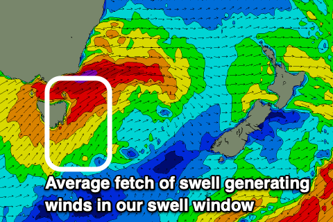
This weekend is looking dicey if you're looking for a surf with a very brief burst of strong S/SW winds expected to be generated in our southern swell window Saturday afternoon as a cold front clips the coast.
 Any increase in size late Saturday will fade overnight with tiny leftovers now likely into Sunday but with favourable offshore W/NW tending W/SW winds.
Monday's swell is a little hit and miss as well now, with the strong polar low that's currently south-west of WA now forecast to push up north-east and across us earlier, resulting in less of a fetch being generated in our swell window.
A stronger fetch of S/SW winds will be projected up past us Sunday evening and early Monday, producing a small pulse of S'ly swell Monday morning to 3-4ft across south magnets.
Winds will improve through the morning, swinging from a SW'ly around to the W and holding all day as the S'ly swell fades.
A secondary poorly aligned front moving through Monday evening should keep 2-3ft sets hitting south magnets on Tuesday with favourable W/NW-W winds.
Following this the storm track will go more zonal again, resulting in tiny to flat surf for our region. So try and make the most of Monday and Tuesday's acute S'ly swells. Have a great weekend!