Pulsey N/NE windswell ahead of a better NE groundswell

Eastern Tasmania Surf Forecast by Craig Brokensha (issued Wednesday 26th June)
Best Days: Sunday morning, later Monday through the end of the week
Recap
Easing S groundswell yesterday, tiny into today.
Today’s Forecaster Notes are brought to you by Rip Curl
This week and next (Jun 27 – Jul 5)
The coming days will remain void of swell but as we move into the weekend, a mid-latitude low squeezing a strong high in the Tasman Sea will generate a significant and better looking fetch of N/NE winds off the southern NSW coast, extending down to us through the afternoon.
 A rapid spike in N/NE windswell is due on Saturday afternoon, reaching 3ft+ by dark but with cross-shore N/NW winds.
A W'ly change will move through overnight and from here the swell will drop rapidly, with Sunday morning not likely to see much above 2ft+ at north-east magnets.
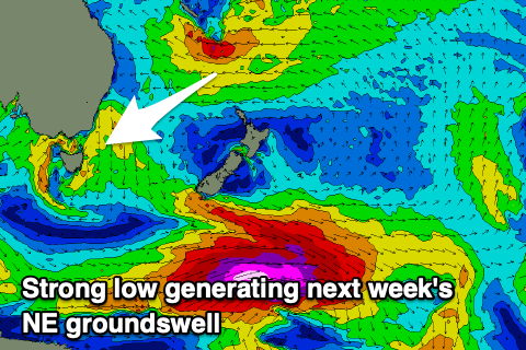
Of greater importance are the developments in the Coral Sea, with the northern flank of the high expected to generate a sustained fetch of E'ly trades, extending into the northern Tasman Sea.
A tropical low will then form in this trade-flow and drift slightly south-west, producing a burst of E gales in our north-eastern swell window through the weekend, weakening slowly into early next week while still being aimed towards us.
We should see a building NE trade-swell come groundswell from later Monday but more so Tuesday, peaking into the afternoon and easing off slowly from Wednesday.
Size wise we're still looking at sets to 4-5ft at the swells peak through Tuesday/Wednesday.
Winds look good and generally offshore, but we'll have a closer look at this on Friday.