Good waves over the coming days

Eastern Tasmania Surf Forecast by Craig Brokensha (issued Friday 21st June)
Best Days: Saturday and Sunday protected spots, Monday and early Tuesday south swell magnets
Recap
Clean easing 3-4ft of S/SE swell yesterday across the coast, while today we've got a new pulse of SE swell to a similar size but with less favourable S/SW winds.
Today’s Forecaster Notes are brought to you by Rip Curl
This weekend and next week (Jun 22 - 28)
Tomorrow will reveal similar sized 3-4ft+ waves out of the SE, generated by a nice low stalling south-east of the state the past two days.
The low has since weakened and is pushing off to the east and with this we'll see the swell dropping into Sunday from 3ft, tiny Monday.
 Winds over the weekend will be best for protected spots with a SW tending S/SE breeze Saturday and SW tending SE wind on Sunday.
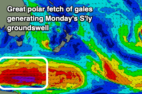
Our new S'ly groundswell for Monday has been upgraded in size, with the polar fetch of W'ly gales now forecast to reach severe-gale to near storm-force over the weekend.
This should produce a great pulse of long-period S'ly groundswell Monday, building through the day and peaking into the afternoon to 4ft across south swell magnets along with a persistent NW offshore wind.
Tuesday looks good as well with a persistent NW offshore as the swell drops rapidly from 2-3ft max.
Longer term there's nothing too major on the cards, but we'll have a closer look at this Monday. Have a great weekend!