Good run of S/SE tending SE swell

Eastern Tasmania Surf Forecast by Craig Brokensha (issued Wednesday 19th June)
Best Days: Thursday, Friday, Saturday and Sunday in protected spots, Monday south magnets
Recap
Nothing of note yesterday, while today an new S'ly swell was on the build, bigger and stronger than forecast on Monday with a tight low forming off the coast. More on this below.
Today’s Forecaster Notes are brought to you by Rip Curl
This week and weekend (Jun 20 - 23)
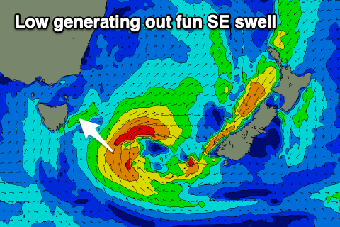
We've got a much better outlook on the cards for the coming days owing to a tight and intense low forming off our coast. This low will stall south-east of us and aim a great fetch of strong E/SE-SE winds towards us over the coming days (after today's localised strong S/SW fetch).
The low will then move on further east out of our swell window Friday evening, but the SE swell should linger into Saturday, fading Sunday.
 So looking at tomorrow and we'll see today's kick in S'ly swell easing rapidly, with 3-4ft sets due to still be breaking across south swell magnets, smaller into the afternoon.
A new increase in SE swell should be seen Friday, kicking open beaches back to 3ft+, with the strongest pulse due early Saturday to 3-4ft, easing later in the day and further from 3ft Sunday.
Winds tomorrow will be great and W'ly most of the day as the swell eases, possibly variable into the afternoon and then SW-S/SW on Friday. Saturday will see similar S/SW winds, though S/SE into the afternoon so hit protected spots, and then S/SW tending SE winds on Sunday.
As the SE swell continues to fade Monday a small hint of new S'ly groundswell is due to be in the mix, generated by a polar fetch of W'ly gales on the weekend. Small 2ft sets are likely at south swell magnets as winds shift back offshore out of the W/NW ahead of N/NE sea breezes.
Longer term there's nothing too significant on the cards so make the most of the coming south-east swell event.