Large good S/SE groundswell to end the week

Eastern Tasmania Surf Forecast by Craig Brokensha (issued Wednesday 29th May)
Best Days: Friday, Saturday, Sunday morning, Tuesday
Recap
A continuation of tiny to flat waves on the coast.
Today’s Forecaster Notes are brought to you by Rip Curl
This week and weekend (May 30 – Jun 2)
Tomorrow is looking suss, with a strong burst of S/SW winds up past our coast not expected to offer much over 3ft across south magnets in the morning, tiny at other beaches.
The swell is due to ease into the afternoon and morning SW winds will shift more W'ly, cleaning up south magnets but with no decent size left.
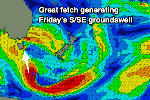 Of greater importance is a large S/SE groundswell due on Friday, generated by a great fetch of gale to severe-gale S/SE winds projected through our swell window today. This fetch will angle away from us tomorrow, but a final little push of S/SW gales should produce a reinforcing swell for the weekend.
The first pulse of S/SE groundswell is expected to fill in Friday and come in at 5-6ft across south magnets with fun waves at open beaches as well. Winds look favourable for more protected spots with a moderate to fresh SW tending S/SW breeze.
Saturday looks great with a light W/SW offshore breeze, tending variable ahead of N/NE sea breezes and a slow drop in size from 4-5ft or so.
Sunday will become more noticeably smaller with clean easing 3ft waves under a W/NW offshore.
Into early next week a polar front and small embedded low moving up past us should kick up a windswelly S/SE swell with average S/SW winds, cleaner as it eases on Tuesday. There might be a reinforcing SE swell from the backside of this low into later next week, but more on this Friday.
Comments
Craig
Just wondering what consitutes a SSE swell. At what degree on the quadrant does it change from S to SSE. Some spots on this coast only really come to life when it has that smidgen of east in it. Only reason I ask is that the surf forecast has Saturday from the S (171-179 degrees) all day but you are calling it a SSE. Cheers
Hi Gary, I'd say anyhing east of 170 would be classified S/SE, but to be technical i'd be the 22.5 degrees between 168.75 and 146.25.
Looking at the source of Saturday's swell I would say just east of south, but not true SSE.