Make the most of tomorrow

Eastern Tasmania Surf Forecast by Craig Brokensha (issued Monday 20th May)
Best Days: Tomorrow south swell magnets
Recap
A small leftover 1-2ft of S'ly swell on Saturday, tiny Sunday morning ahead of a new S'ly groundswell into the afternoon.
This swell has held in this morning with clean conditions, and it should have eased this afternoon ahead of a late pulse of new long-period S'ly groundswell (discussed below).
Today’s Forecaster Notes are brought to you by Rip Curl
This week and weekend (May 21 -26)
A new S'ly groundswell due later today but more so tomorrow is the second generated by back to back polar lows moving through our swell window over the weekend. This secondary system was a bit stronger than forecast on Friday, with a fetch of severe-gale to storm-force W/NW winds generated through our swell window.
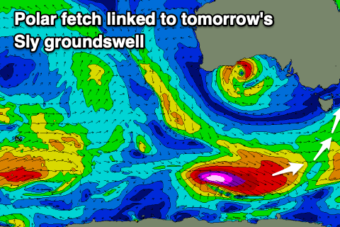 The swell is due to arrive overnight and ease back through tomorrow from 3ft across south magnets, small to tiny elsewhere.
Conditions will be great all day with a W/NW-NW offshore, clean again Wednesday but on the small to tiny side with a distant SE pulse in the water. This may produce inconsistent 1-2ft sets Wednesday afternoon and Thursday morning, though keep your expectations very low.
Unfortunately there's nothing significant on the cards for the rest of the period as a zonal flow is setup across the state.
This may change into next week as a strong node of the Long Wave Trough slowly moves in from the west, shifting the storm track more up past us, but we'll have a closer look at this Wednesday.