Fun N/NE windswell this week

Eastern Tasmania Surf Forecast by Craig Brokensha (issued Monday 29th April)
Best Days: Wednesday north-east facing beaches, Friday morning, next Monday
Recap
Saturday's trickiest S'ly swell failed to show any real size, while Sunday was much better with the more reliable S'ly groundswell offering great waves with offshore winds.
The swell has eased back into this morning from a good and fun 2-3ft with varying but generally offshore winds.
Today’s Forecaster Notes are brought to you by Rip Curl
This week and weekend (Apr 30 – May 5)
There isn't expected to be much left in the tank out of the S'th tomorrow, with the S'ly swell due to drop back leaving 1-2ft sets at south magnets.
This week is looking a little more active with small levels of N/NE windswell now on the cards from Wednesday through Friday as a stubborn high sits in the Tasman Sea, squeezed by a multi-centred and slow moving low drifting in from the west.
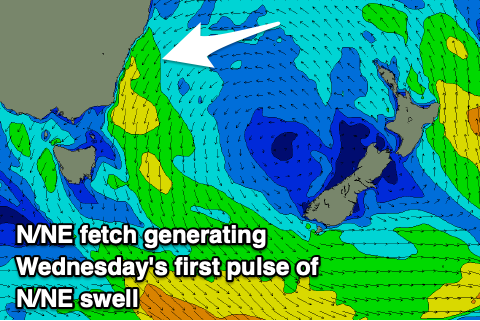 Wednesday will see a small increase in N/NE energy from a good fetch of N/NE winds off the southern NSW coast, building to 2-3ft through the morning, if not from dawn and peaking into the afternoon. Winds look variable and possibly NW into the afternoon creating favourable conditions.
The N/NE fetch will become more localised on Thursday keeping the surf around a more windswelly 2-3ft with fresh N/NE winds.
Friday looks better as the N/NE windswell eases from 2-3ft with a NW offshore.
Longer term we've got some interesting and varying developments as the models diverge on what the broad low will do once it enters the Tasman Sea.
There's a few possibilities but we may see some good E/SE swell through next week, while a polar front is likely to generate a good S'ly groundswell for Monday as well. More on this next update though.