Much slower week with only a couple of surf days

Eastern Tasmania Surf Forecast by Craig Brokensha (issued Monday 22nd April)
Best Days: Tuesday morning, Saturday morning south swell magnets
Recap
A fun new S/SE swell with morning offshores Saturday and afternoon sea breezes and a building N/NE windswell, mixed in with some trade-swell yesterday.
This morning the surf was clean and easing out of the N/NE and E/NE from a good 2-3ft.
Today’s Forecaster Notes are brought to you by Rip Curl
This week and weekend (Apr 23 - 28)
I hope you've made the most of the surf over the weekend as the swell will continue to decline tomorrow, becoming tiny Wednesday.
With the trade-fetch above New Zealand breaking down over the weekend, there's no new swell energy due across the coast with easing sets from an inconsistent 2ft on the open beaches with a NW tending NE breeze.
Wednesday may still see the odd 1-2ft wave, but it'll be mostly tiny though clean.
 As touched on last update, we'll see a strong zonal flow setup across the state later week and into the weekend as back to back frontal systems move in and across us.
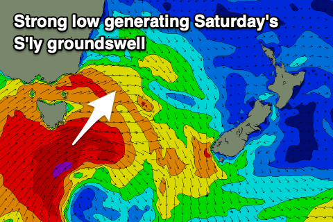
All of the fetches will be too west to generate any swell for us until Saturday. This will be when the strongest of the fronts moves across us Friday, directing a slightly better aligned fetch of severe-gale SW winds through our swell window into the afternoon.
This should produce a small fun pulse of S'ly groundswell for Saturday to 3ft across south magnets, tiny to flat at other locations.
Winds look great and gusty out of the W/NW tending W/SW as another front passes across us.
This secondary front looks a bit too west again to generate any reinforcing swell, with the surf becoming small to tiny Sunday.
Into next week though we'll see the storm track take a more favourable north-east angle, producing small S'ly swells, but more on this Wednesday.