Swells from all directions with winds also swinging around

Eastern Tasmania Surf Forecast by Craig Brokensha (issued Friday 19th April)
Best Days: Northern corners Saturday and Sunday, southern corners Monday morning
Recap
Great waves yesterday with a clean easing N/NE swell from 3-4ft, while today we should of fallen in between swells.
Today’s Forecaster Notes are brought to you by Rip Curl
This weekend and next week (Apr 20 - 26)
Moiving into the weekend and we should see a fun mix of building E/NE trade-swell, N/NE windswell and new S/SE groundswell on the coast tomorrow.
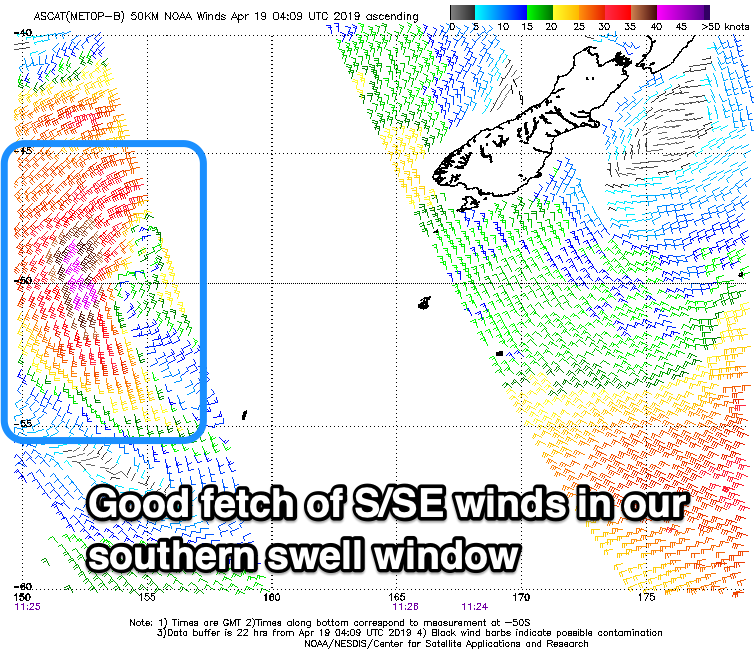 The S/SE swell will be best, generated yesterday and last night by a small tight low stalling south-southeast of us.
Satellite observations have confirmed a great fetch of strong to gale-force S'ly winds in our southern swell window, with sets to 3ft across south magnets most of the day, easing later and small to tiny Sunday.
Early light N'ly winds will quickly strengthen from the N/NE, favouring south magnets while the windswell should build to a small 2ft+ later. The trade-swell from above New Zealand is pushing in strong across the NSW North Coast and has just hit Sydney.
We'll see sets pushing 3ft later tomorrow afternoon and holding Sunday before easing Monday.
The N/NE windswell looks to come in a small and weaker 2-3ft Sunday and a swing in winds from the N/NE in the morning to N/NW later afternoon should create improving conditions.
Monday looks dicey for open beaches with a weak S'ly change at dawn, but north-east magnets should be clean with a mix of fading E/NE trade-swell and N/NE windswell from 2ft to possibly 3ft.
We'll see the trade-swell continuing to slowly ease through the week with nothing significant on the cards until later next week and weekend in the form of small refracted south swells. So with this in mind make the most of the coming days of swell. Have a happy and safe Easter!