Small S swell tomorrow followed by swell from the north-eastern quadrant

Eastern Tasmania Surf Forecast by Craig Brokensha (issued Friday 12th April)
Best Days: Saturday morning south swell magnets, later Wednesday northern corners, Thursday
Recap
A small fun S'ly swell yesterday, while there should have been some swell still in the tank this morning.
Today’s Forecaster Notes are brought to you by Rip Curl
This weekend and next week (Apr 13 - 19)
Another small pulse of S'ly swell is due tomorrow morning, generated by a strong fetch of SW winds on the polar shelf Wednesday evening and yesterday morning.
Satellite observations show winds were as forecast if not a little stronger and we'll hopefully see 2-3ft of S'ly groundswell tomorrow morning with a W'ly offshore ahead of a midday S'ly change.
Sunday will be poor with no swell and onshore S/SE tending SE winds as a ridge of high pressure moves in from the south-west behind Saturday's change.
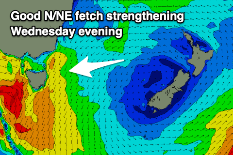
The north-east fetch developing down our coast looks a touch delayed now, with no real strength in it due until mid week.
 Ahead of this, small weak levels of E/NE swell are due to build to 1-2ft Monday afternoon and persist around 2ft on Tuesday but with onshore NE winds on the former, more N/NE on the later.
Through Wednesday we'll see a more noticeable increase in N/NE swell as N/NE winds strengthen down the coast, kicking up an increase in windswell from 2-3ft to a more consistent 3ft later in the day.
Winds will become strongest just ahead of a strengthening cold front early Thursday morning, with the N/NE swell peaking around 4ft across north-east magnets though easing rapidly behind a W/NW change.
The models diverge on the timing of the change and the eventual strength of the fetch down our coast and hence the size of the N/NE swell, as well as developments on the northern flank of the high, generating our E/NE trade-swell.
We'll have to go over this again on Monday but as the N/NE windswell eases we should see fun levels of E/NE trade-swell to replace it through Friday and the weekend. EC has the swell becoming large as a tropical low forms then retro-grades south-west towards us but GFS is divergent.
More on all of this on Monday. Have a great weekend!