Small N/NE energy followed by a better run of S swell

Eastern Tasmania Surf Forecast by Craig Brokensha (issued Thursday 28th March)
Best Days: Saturday morning north-east swell magnets, Sunday morning for a flukey south swell, better Monday and Tuesday
Recap
Tiny surf today with a micro hint of southerly swell.
Today’s Forecaster Notes are brought to you by Rip Curl
Tomorrow through next week (Mar 29 – Apr 5)
We've got a better though tricky outlook over the coming days with a small N/NE windswell due to be replaced by a close-range S'ly swell event.
A vigorous cold front that's currently pushing through the Bight will squeeze a high that's over near New Zealand, bringing a patchy fetch of strong N/NE winds through our north-eastern swell window this evening and tomorrow.
With the fetch being so patchy and at times sitting off the coast I'd keep expectations low, with only a tiny 1-1.5ft of swell due tomorrow morning, increasing a touch to possibly 2ft through the afternoon.
 A more consolidated but distant fetch of N/NE winds off the southern NSW coast Friday evening should keep similar 2ft sets hitting north-east magnets Saturday morning before fading through the day.
Winds tomorrow should be offshore and out of the W/NW through the morning, fresher from the N-N/NE through the afternoon, while Saturday will be best early with a W/SW offshore, strengthening from the south through the afternoon and evening as the cold front from the Bight pushes across us.
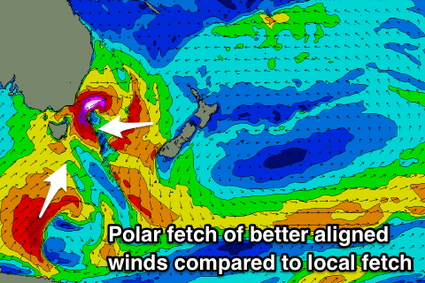
Now, this is where things get tricky, as the front moves across us it will strengthen, with a fetch of strong to gale-force S/SW winds forming east and north of us. In our swell window winds will be weaker and this will put a cap on the expected size due from this frontal system, with it coming in way under model forecasts.
A peak in size is likely Sunday morning but only to 3ft or so across south swell magnets, small to tiny at other locations and with W/SW tending S'ly winds.
A better pulse of reinforcing S'ly swell is likely Monday as a more favourable fetch of polar S/SW winds developing from the south-east corner of the state down to the polar shelf Saturday evening and Sunday.
With the fetch being positioned further away this will allow the swell to spread up and into the coast more favourably, with south facing beaches due to offer more consistent and defined 3ft waves.
Winds look favourable and light from the W/SW, tending variable ahead of NE sea breezes.
There should still be a bit of size to 2-3ft on Tuesday with all day NW offshore winds, clean again Wednesday morning but on the tiny side.
Longer term nothing really stands out, but more on this Monday. Have a good Friday and weekend!