Small unreliable swells for the period

Eastern Tasmania Surf Forecast by Craig Brokensha (issued Monday 11th February)
Best Days: Thursday morning south swell magnets, late Satuday south magnets and Sunday south magnets, Monday through Wednesday open beaches
Recap
No size left over into Saturday with clean tiny 1ft waves, increasing a touch out of the south to 1-2ft on Sunday, tiny again today.
Today’s Forecaster Notes are brought to you by Rip Curl
This week and weekend (Feb 12 - 17)
The coming forecast period is full of flukey small swells out of the south and east-northeast.
The southerly energy will be generated initially by poorly aligned but strong storm activity in the Southern Ocean.
The first of which should be seen on Wednesday afternoon and Thursday morning as a deep and powerful low forms south of the state tomorrow.
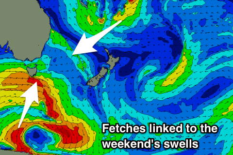 A tight fetch of severe-gale to storm-force W/SW-SW winds will be generated, with the tail of the low generating a fetch of S/SW winds just within our swell window Wednesday morning.
This should generate a small spike in S'ly swell late in the day but more so Thursday morning to 2ft to maybe 3ft across south swell magnets, easing rapidly through the day. Conditions will be clean with a W/NW offshore.
The surf is then likely to go tiny to flat into the weekend ahead of a small increase in S/SW swell Sunday mixed in with some long-range E/NE swell.
The S'ly energy will be generated on the backside of the low forming tomorrow, with a polar fetch of S/SE gales just a little too west to be ideal due to be followed by a better aimed though weaker fetch of W/SW winds.
The S/SE fetch may produce a small S'ly groundswell spike late Saturday to 2ft, but Sunday should reveal the better aligned swell with 2-3ft sets on the south magnets.
The E/NE swell will be produced by a distant and small weak though favourably aligned and tracking burst of strong E/NE winds south of Fiji down towards the Tasman Sea through Thursday, with a secondary similar development Saturday.
There'll be a fair bit of swell decay but we should see inconsistent 2ft sets out of the E/NE from Sunday through early next week. Winds on Sunday will only be favourable for south magnets though with a N/NW tending N/NE breeze, offshore from the W/NW Monday.
This swell may persist through most of next week as we see reinforcing energy spreading radially off a strong ridge sitting across the northern Tasman Sea, but more on this Wednesday.