Fun E'ly swell, cleanest as it eases

Eastern Tasmania Surf Forecast by Craig Brokensha (issued Monday 4th February)
Best Days: Wednesday and Thursday keen surfers, Friday
Recap
Building windswell through the weekend, peaking yesterday morning to 2-3ft across north-east facing beaches, fading back into this morning.
Today’s Forecaster Notes are brought to you by Rip Curl
This week and weekend (Feb 5 - 10)
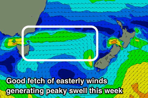
We've got some fun E/NE tending NE swell on the cards this week as a strong high moving in from the west is squeezed on its northern flank by a low pressure trough.
A fetch of strong E/SE tending E/NE winds will be aimed through our eastern swell window, before swinging more NE into Thursday and then away from us into the afternoon.
 We should see fun levels of swell filling in from Wednesday, with tomorrow being small to tiny and onshore out of the S/SE tending E/SE.
Winds will remain onshore out of the E/NE Wednesday as the swell builds towards 3ft on the open beaches, peaking Thursday to a good 3ft to occasionally 4ft as those winds swing from N/NE to N/NW later in the day.
Friday will be nice and clean but the surf easing from a fun 2-3ft.
Coming back to Wednesday and also in the mix should be our S/SE groundswell from a polar fetch of gales over the weekend. This should keep south facing beaches topped up with additional 3ft sets
The swell will be all but gone into the weekend and the tropical activity occurring north of New Zealand will be poorly aimed and too distant to generate any considerable size for us.
Instead we'll see the westerly storm track fire up under the influence of a strong node of the Long Wave Trough. This doesn't look to bring anything for us until maybe mid-next week, but more on this Wednesday.