Small mixes of NE and S/SE swells

Eastern Tasmania Surf Forecast by Craig Brokensha (issued Monday 17th December)
Best Days: Tomorrow morning protected spots, early Wednesday, Friday morning keen surfers
Recap
Large though bumpy waves on Saturday with poor weather, cleaner through Sunday though still hard with tricky fog.
This morning was much cleaner and with fun sized sets easing from 3-5ft across the north-east swell magnets.
Today’s Forecaster Notes are brought to you by Rip Curl
This week and weekend (Dec 18 - 23)
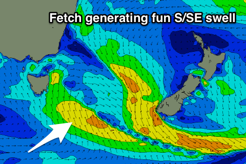
Our current NE swell will continue to fade through tomorrow, but we've had an upgrade in the S/SE swell off a surface trough drifting in and across us this afternoon.
North-east facing beaches are due to ease back from a small 2ft on the sets, tiny through the day, but a fetch of strong S/SE winds moving up our coast this evening will extend south-east of us, with a fun sized S/SE swell on the cards for tomorrow.
 We should see the swell strengthening in power through the day, building to 3ft+ but with gusty S/SW tending S/SE winds.
Wednesday is looking better with a more variable and likely local offshore wind and easing 2-3ft sets out of the SE.
The easing trend will be slow, with small 1-2ft waves hanging in Thursday morning but with a N'ly tending NE breeze.
A deepening surface trough drifting in from the north-west will again aim a fetch of strong but short-lived NE fetch through our north-eastern swell window Thursday, producing a small pulse of NE swell for Friday morning.
Size wise it looks only to be a small 2ft max across north-east swell magnets, fading through the day and with favourable S/SW tending S/SE winds for those north facing breaks.
Come Saturday there isn't expected to be any size left on the coast with nothing too significant on the cards heading into Christmas week as a vigorous frontal progression fires up and pushes across us.
Therefore make the most of the little swell due over the coming days.