Stormy swells developing, cleaning up from late in the weekend

Eastern Tasmania Surf Forecast by Craig Brokensha (issued Wednesday 12th December)
Best Days: Later Sunday for experienced surfers, Monday southern corners
Recap
No surfable waves the last couple of days, but we've got plenty of swell inbound.
Today’s Forecaster Notes are brought to you by Rip Curl
This week and weekend (Dec 13 - 16)
We should be seeing a strengthening NE wind on the coast this afternoon and a small junky increase in NE windswell, but tomorrow will reveal much more energy as a strong fetch of persistent NE winds remain in our swell window all of tomorrow.
This will be linked to a deepening mid-latitude low stalling across inland Victoria and NSW, with embedded coastal troughs directing bursts of stronger E/NE winds through our swell window over the coming few days.
 We'll see the NE swell energy building 3ft+ tomorrow morning, upwards of 4-5ft later in the day with strong onshore NE tending E/NE winds.
The swell should then steady and swing more E/NE in direction on Friday owing to the fetch swinging more E/NE off our coast.
Most open beaches are due to see 4-6ft surf but with strong and poor onshore E/SE winds.
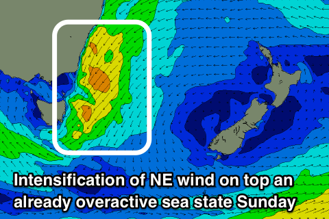
Into the weekend we'll see an embedded trough project another burst of strong NE winds down towards us through Saturday and Sunday, producing larger levels of NE swell as these fetches act on top an active sea state, building to 5-6ft+ later in the day Saturday and peaking Sunday to 6-8ft.
Winds will remain poor and onshore out of the E/SE tending E on Saturday, veering back NE on Sunday and easing as the low starts to drift south-east.
We should see winds tending N/NW on dark creating cleaner conditions and decent options in northern corners with the large NE swell event.
Monday is looking the pick across southern corners with a gusty S/SW tending S/SE change as the western flank of the low moves across us along with easing 5-6ft sets. The change will also bring a new S'ly windswell for later Monday and more so Tuesday morning to 4-5ft or so. We'll have a closer look at this and one final look at the size due on the weekend Friday.